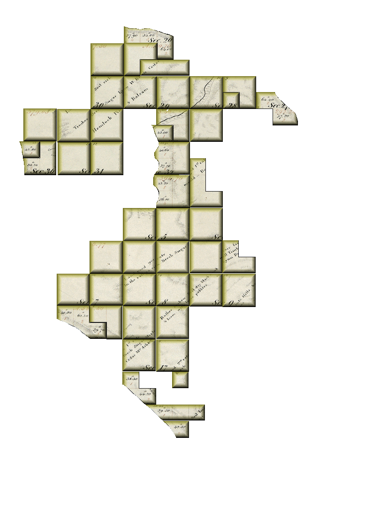
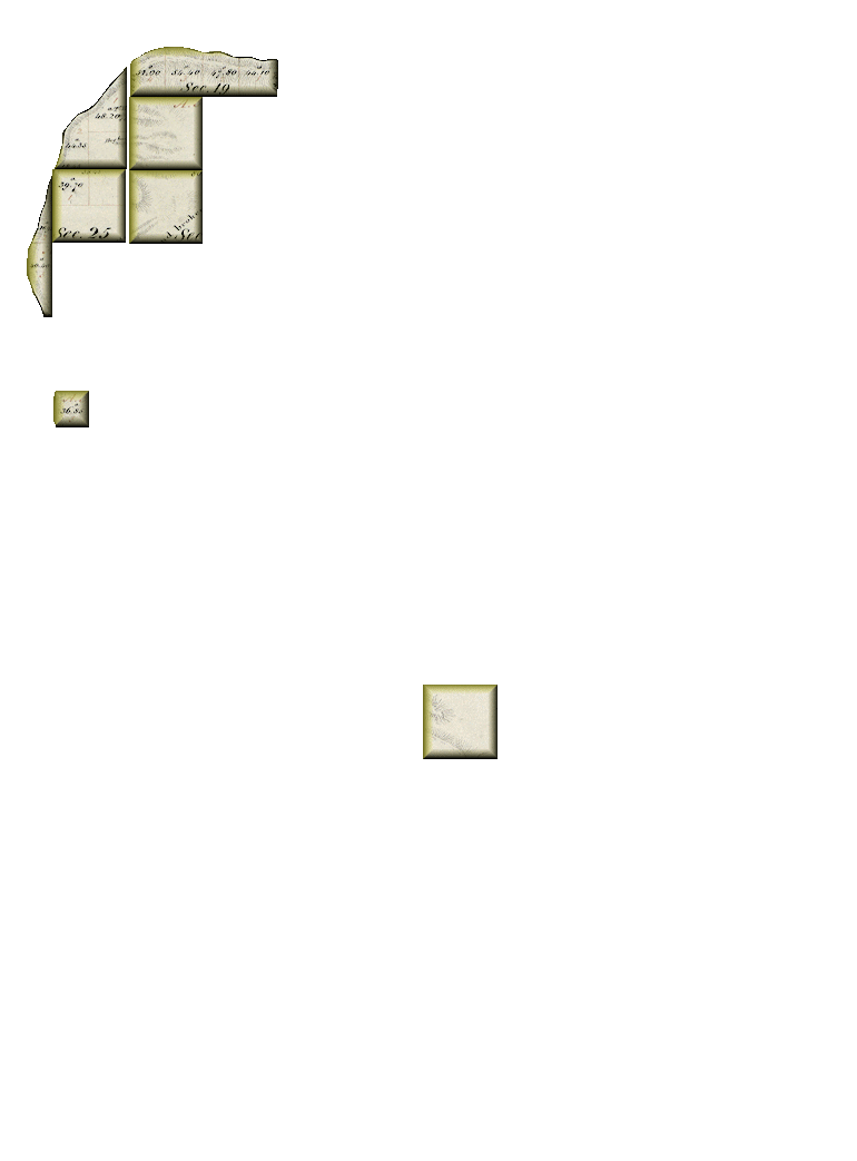
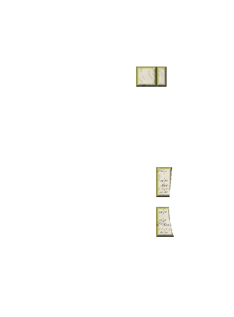
Original Land Ownership - North Mantiou Island

- Lars C Alstrom
- Homestead Entry
- E½SW-21/T31N,R14W; W½SE-21/T31N,R14W
- 160-Acres
- Filing: Dec 19, 1884
- Land Office: Grayling
- Patent: Nov 2, 1891
- File No. MI3110__.054
-
- Andrew Anderson
- Homestead Entry
- 3-20/T31N,R14W; SWNW-21/T31N,R14W; W½SW-21/T31N,R14W; 1-28/T31N,R14W
- 159.4-Acres
- Filing: Sep 6, 1875
- Land Office: Reed City
- Patent: Sep 15, 1883
- File No. MI3080__.108
-
- Andrew Anderson
- Sale-Cash Entry
- SWSW-15/T31N,R14W
- 40-Acres
- Filing:
- Land Office: Reed City
- Patent: Apl 5, 1889
- File No. MI2960__.163
-
- John Andersen
- Homestead Entry
- W½NW-22/T31N,R14W; W½SW-22/T31N,R14W
- 160-Acres
- Filing: Apl 22, 1890
- Land Office: Grayling
- Patent: May 29, 1896
- File No. MI3110__.401
-
- George Aylesworth
- Sale-Cash Entry
- NESE-31/T32N,R14W
- 40-Acres
- Filing:
- Land Office: Traverse City
- Patent: Jul 10, 1865
- File No. MI2400__.200
-
- Albert Bacon
- Scrip/Warrant
- S½SE-4/T31N,R14W; NWSE-4/T31N,R14W
- 120-Acres
- Filing:
- Land Office: Traverse City
- Patent: Jan 2, 1862
- File No. MW-0142-141
-
- Albert Bacon
- Sale-Cash Entry
- 1-7/T31N,R14W; 2-7/T31N,R14W; 3-7/T31N,R14W
- 142.8-Acres
- Filing:
- Land Office: Traverse City
- Patent: Nov 15, 1862
- File No. MI2390__.469
-
- Albert Bacon
- Sale-Cash Entry
- 1-17/T31N,R14W; 2-17/T31N,R14W; NESE-17/T31N,R14W
- 122.5-Acres
- Filing:
- Land Office: Traverse City
- Patent: Nov 15, 1862
- File No. MI2390__.470
-
- Albert Bacon
- Sale-Cash Entry
- 1-17/T31N,R14W; 2-17/T31N,R14W; NESE-17/T31N,R14W
- 122.5-Acres
- Filing:
- Land Office: Traverse City
- Patent: Nov 15, 1862
- File No. MI2390__.470
-
- Albert Bacon
- Sale-Cash Entry
- 2-20/T31N,R14W
- 42.5-Acres
- Filing:
- Land Office: Traverse City
- Patent: Nov 15, 1862
- File No. MI2390__.471
-
- Albert Bacon
- Sale-Cash Entry
- 2-20/T32N,R14W; 3-20/T32N,R14W; 4-20/T32N,R14W
- 135.9-Acres
- Filing:
- Land Office: Traverse City
- Patent: Nov 15, 1862
- File No. MI2390__.475
-
- Albert Bacon
- Sale-Cash Entry
- SWNE-28/T32N,R14W
- 40-Acres
- Filing:
- Land Office: Traverse City
- Patent: Nov 15, 1862
- File No. MI2390__.476
-
- Albert Bacon
- Sale-Cash Entry
- 1-29/T32N,R14W
- 43-Acres
- Filing:
- Land Office: Traverse City
- Patent: Nov 15, 1862
- File No. MI2390__.477
-
- Albert Bacon
- Scrip/Warrant
- 1-36/T32N,R15W
- 42.8-Acres
- Filing:
- Land Office: Traverse City
- Patent: Nov 15, 1862
- File No. MI2390__.478
-
- Albert Bacon
- Scrip/Warrant
- SE-6/T31N,R14W
- 160-Acres
- Filing:
- Land Office: Traverse City
- Patent: Jan 2, 1863
- File No. MW-0142-131
-
- Albert Bacon
- Scrip/Warrant
- NW-9/T31N,R14W
- 160-Acres
- Filing:
- Land Office: Traverse City
- Patent: Jan 2, 1863
- File No. MW-0142-133
-
- Albert Bacon
- Scrip/Warrant
- SW-28/T32N,R14W
- 160-Acres
- Filing:
- Land Office: Traverse City
- Patent: Jan 2, 1863
- File No. MW-0142-123
-
- Albert Bacon
- Scrip/Warrant
- NW-28/T32N,R14W
- 160-Acres
- Filing:
- Land Office: Traverse City
- Patent: Jan 2, 1863
- File No. MW-0142-138
-
- Albert Bacon
- Scrip/Warrant
- NW-5/T31N,R14W
- 160-Acres
- Filing:
- Land Office: Traverse City
- Patent: Jan 2, 1863
- File No. MW-0142-132
-
- Albert Bacon
- Scrip/Warrant
- NW-7/T31N,R14W
- 160-Acres
- Filing:
- Land Office: Traverse City
- Patent: Jan 2, 1863
- File No. MW-0142-140
-
- Albert Bacon
- Scrip/Warrant
- SE-5/T31N,R14W
- 160-Acres
- Filing:
- Land Office: Traverse City
- Patent: Jan 2, 1863
- File No. MW-0142-130
-
- Albert Bacon
- Scrip/Warrant
- NE-7/T31N,R14W
- 160-Acres
- Filing:
- Land Office: Traverse City
- Patent: Jan 2, 1863
- File No. MW-0142-128
-
- Albert Bacon
- Scrip/Warrant
- SW-5/T31N,R14W
- 160-Acres
- Filing:
- Land Office: Traverse City
- Patent: Jan 2, 1863
- File No. MW-0142-129
-
- Albert Bacon
- Scrip/Warrant
- NW-8/T31N,R14W
- 160-Acres
- Filing:
- Land Office: Traverse City
- Patent: Jan 2, 1863
- File No. MW-0142-135
-
- Albert Bacon
- Scrip/Warrant
- SW-4/T31N,R14W
- 160-Acres
- Filing:
- Land Office: Traverse City
- Patent: Jan 2, 1863
- File No. MW-0142-136
-
- Albert Bacon
- Scrip/Warrant
- NE-9/T31N,R14W
- 160-Acres
- Filing:
- Land Office: Traverse City
- Patent: Jan 2, 1863
- File No. MW-0142-124
-
- Albert Bacon
- Scrip/Warrant
- S½SW-33/T32N,R14W; NWSW-33/T32N,R14W; SWNW-33/T32N,R14W
- 160-Acres
- Filing:
- Land Office: Traverse City
- Patent: Jan 2, 1863
- File No. MW-0142-122
-
- Albert Bacon
- Scrip/Warrant
- E½SE-32/T32N,R14W; 4-32/T32N,R14W; 5-32/T32N,R14W
- 159.3-Acres
- Filing:
- Land Office: Traverse City
- Patent: Jan 2, 1863
- File No. MW-0142-142
-
- Albert Bacon
- Scrip/Warrant
- NE-8/T31N,R14W
- 160-Acres
- Filing:
- Land Office: Traverse City
- Patent: Jan 2, 1863
- File No. MW-0142-125
-
- Albert Bacon
- Scrip/Warrant
- NW-4/T31N,R14W
- 160-Acres
- Filing:
- Land Office: Traverse City
- Patent: Jan 2, 1863
- File No. MW-0142-137
-
- Albert Bacon
- Scrip/Warrant
- SW-8/T31N,R14W
- 160-Acres
- Filing:
- Land Office: Traverse City
- Patent: Jan 2, 1863
- File No. MW-0142-134
-
- Albert Bacon
- Scrip/Warrant
- SE-8/T31N,R14W
- 160-Acres
- Filing:
- Land Office: Traverse City
- Patent: Jan 2, 1863
- File No. MW-0142-127
-
- Albert Bacon
- Scrip/Warrant
- E½NE-32/T32N,R14W; 1-32/T32N,R14W; 6-32/T32N,R14W
- 157.8-Acres
- Filing:
- Land Office: Traverse City
- Patent: Jan 2, 1863
- File No. MW-0142-139
-
- Albert Bacon
- Scrip/Warrant
- NE-5/T31N,R14W
- 160-Acres
- Filing:
- Land Office: Traverse City
- Patent: Jan 2, 1863
- File No. MW-0142-126
-
- Albert Bacon
- Scrip/Warrant
- NW-29/T32N,R14W
- 160-Acres
- Filing:
- Land Office: Traverse City
- Patent: Mar 16, 1863
- File No. MW-0142-164
-
- Albert Bacon
- Scrip/Warrant
- S½SE-20/T32N,R14W; SESW-20/T32N,R14W
- 120-Acres
- Filing:
- Land Office: Traverse City
- Patent: Mar 16, 1863
- File No. MW-0142-158
-
- Albert Bacon
- Scrip/Warrant
- 1-20/T31N,R14W; NENE-20/T31N,R14W; NWNW-21/T31N,R14W
- 119.5-Acres
- Filing:
- Land Office: Traverse City
- Patent: Mar 16, 1863
- File No. MW-0142-157
-
- Albert Bacon
- Scrip/Warrant
- E½SE-7/T31N,R14W; NWSE-7/T31N,R14W
- 120-Acres
- Filing:
- Land Office: Traverse City
- Patent: Mar 16, 1863
- File No. MW-0142-156
-
- Albert Bacon
- Scrip/Warrant
- NE-31/T32N,R14W
- 160-Acres
- Filing:
- Land Office: Traverse City
- Patent: Mar 16, 1863
- File No. MW-0142-175
-
- Albert Bacon
- Scrip/Warrant
- E½NE-28/T32N,R14W; NWNE-28/T32N,R14W
- 120-Acres
- Filing:
- Land Office: Traverse City
- Patent: Mar 16, 1863
- File No. MW-0142-172
-
- Albert Bacon
- Scrip/Warrant
- E½NE-36/T32N,R15W; 2-36/T32N,R15W
- 118.2-Acres
- Filing:
- Land Office: Traverse City
- Patent: Mar 16, 1863
- File No. MW-0142-176
-
- Albert Bacon
- Scrip/Warrant
- W½SW-20/T32N,R14W; NESW-20/T32N,R14W
- 120-Acres
- Filing:
- Land Office: Traverse City
- Patent: Mar 16, 1863
- File No. MW-0142-159
-
- Albert Bacon
- Scrip/Warrant
- SW-30/T32N,R14W
- 160-Acres
- Filing:
- Land Office: Traverse City
- Patent: Mar 16, 1863
- File No. MW-0142-173
-
- Albert Bacon
- Scrip/Warrant
- N½SE-29/T32N,R14W; SESE-29/T32N,R14W
- 120-Acres
- Filing:
- Land Office: Traverse City
- Patent: Mar 16, 1863
- File No. MW-0142-160
-
- Albert Bacon
- Scrip/Warrant
- SE-30/T32N,R14W
- 160-Acres
- Filing:
- Land Office: Traverse City
- Patent: Mar 16, 1863
- File No. MW-0142-166
-
- Albert Bacon
- Scrip/Warrant
- NW-31/T32N,R14W
- 160-Acres
- Filing:
- Land Office: Traverse City
- Patent: Mar 16, 1863
- File No. MW-0142-174
-
- Albert Bacon
- Scrip/Warrant
- NW-17/T31N,R14W
- 160-Acres
- Filing:
- Land Office: Traverse City
- Patent: Mar 16, 1863
- File No. MW-0142-171
-
- Albert Bacon
- Scrip/Warrant
- NE-30/T32N,R14W
- 160-Acres
- Filing:
- Land Office: Traverse City
- Patent: Mar 16, 1863
- File No. MW-0142-165
-
- Albert Bacon
- Scrip/Warrant
- SE-19/T32N,R14W
- 160-Acres
- Filing:
- Land Office: Traverse City
- Patent: Mar 16, 1863
- File No. MW-0142-163
-
- Albert Bacon
- Sale-Cash Entry
- 2-27/T32N,R14W; 3-27/T32N,R14W
- 121.6-Acres
- Filing:
- Land Office: Traverse City
- Patent: May 15, 1863
- File No. MI2390__.483
-
- Albert Bacon
- Scrip/Warrant
- SE-25/T32N,R15W
- 160-Acres
- Filing:
- Land Office: Traverse City
- Patent: May 20, 1863
- File No. MW-0142-209
-
- Albert Bacon
- Scrip/Warrant
- NE-29/T32N,R14W
- 160-Acres
- Filing:
- Land Office: Traverse City
- Patent: Apr 15, 1864
- File No. MW-0142-284
-
- Albert Bacon
- Scrip/Warrant
- NE-17/T31N,R14W
- 160-Acres
- Filing:
- Land Office: Traverse City
- Patent: Apr 15, 1864
- File No. MW-0142-285
-
- John J Bagley
- Scrip/Warrant
- 1-19/T32N,R14W; 2-19/T32N,R14W; 3-19/T32N,R14W; 4-19/T32N,R14W
- 197.3-Acres
- Filing:
- Land Office: Traverse City
- Patent: Sep 5, 1865
- File No. MW-0142-466
-
- John J Bagley
- Sale-Cash Entry
- 2-25/T32N,R15W; 3-25/T32N,R15W
- 59.35-Acres
- Filing:
- Land Office: Traverse City
- Patent: Feb 6, 1866
- File No. MI2400__.308
-
- John J Bagley
- Sale-Cash Entry
- 3-36/T32N,R15W
- 36.85-Acres
- Filing:
- Land Office: Traverse City
- Patent: Feb 6, 1866
- File No. MI2400__.309
-
- John J Bagley
- State Grant - Agri College
- SW19/T32N,R14W
- 160-Acres
- Filing:
- Land Office: Traverse City
- Patent: May 1, 1867
- File No. AGS-0014-020
-
- John J Bagley
- State Grant - Agri College
- 29/T32N,R15W (Sectional)
- 132.55-Acres
- Filing:
- Land Office: Traverse City
- Patent: May 1, 1867
- File No. AGS-0014-025
-
- John J Bagley
- State Grant - Agri College
- NW30/T32N,R14W
- 160-Acres
- Filing:
- Land Office: Traverse City
- Patent: May 1, 1867
- File No. AGS-0014-021
-
- John J Bagley
- State Grant - Agri College
- NE25/T32N,R15W
- 159.7-Acres
- Filing:
- Land Office: Traverse City
- Patent: May 1, 1867
- File No. AGS-0014-022
-
- John J Bagley
- State Grant - Agri College
- SW9/T32N,R14W
- 160-Acres
- Filing:
- Land Office: Traverse City
- Patent: May 1, 1867
- File No. AGS-0014-019
-
- Fredric Benham
- Homestead Entry
- N½NW-33/T32N,R14W; SENW-33/T32N,R14W; NESW-33/T32N,R14W
- 160-Acres
- Filing: Jun 4, 1881
- Land Office: Grayling
- Patent: Feb 4, 1891
- File No. MI3100__.500
-
- Alvar Bournique
- Homestead Entry
- E½NW-22/T31N,R14W; NESW-22/T31N,R14W; 5-22/T31N,R14W
- 152.2-Acres
- Filing: Jul 3, 1903
- Land Office: Marquette
- Patent: May 17, 1909
- File No. 62772
-
- Nels Carlsen
- Homestead Entry
- SE-9/T31N,R14W
- 160-Acres
- Filing:
- Land Office: Marquette
- Patent: Mar 20, 1905
- File No. MI3120__.451
-
- Nickolas Feilen
- Homestead Entry
- E½SE-21/T31N,R14W; 27/T31N,R14W; 4-28/T31N,R14W
- 140.2-Acres
- Filing: Aug 28, 1903
- Land Office: Marquette
- Patent: May 19, 1910
- File No. 131334
-
- Hendrik Fredriksen
- Sale-Cash Entry
- 2-22/T31N,R14W
- 68-Acres
- Filing: 1883
- Land Office: Reed City
- Patent: May 20, 1885
- File No. MI2950__.478
-
- Peter Hansen
- Homestead Entry
- E½NW-21/T31N,R14W
- 80-Acres
- Filing: Oct 4, 1886
- Land Office: Grayling
- Patent: May 28, 1895
- File No. MI3110__.353
-
- Lyman Judson
- Sale-Cash Entry
- SESE-17/T31N,R14W; W½SE-17/T31N,R14W; NESW-17/T31N,R14W
- 160-Acres
- Filing:
- Land Office: Reed City
- Patent: Jan 7, 1885
- File No. MI2950__.376
-
- John Maleske (Maleski)
- Homestead Entry
- SWSE-21/T32N,R14W; 1-21/T32N,R14W
- 96.3-Acres
- Filing: May 16, 1912
- Land Office: Marquette
- Patent: Jun 24, 1919
- File No. 690133
-
- Reuben McCreary (or McCreery)
- Scrip/Warrant
- 4-1/T31N,R15W; 1-12/T31N,R15W; 2-12/T31N,R15W
- 178-Acres
- Filing:
- Land Office: Traverse City
- Patent: May 20, 1863
- File No. MW-0142-219
-
- Niel McFadyen
- Sale-Cash Entry
- 2-3/T31N,R14W
- 16-Acres
- Filing:
- Land Office: Saullt Ste. Marie
- Patent: Feb 1, 1849
- File No. MI1960__.139
-
- Niel McFadyen
- Sale-Cash Entry
- 1-22/T31N,R14W
- 28.75-Acres
- Filing:
- Land Office: Saullt Ste. Marie
- Patent: Feb 1, 1849
- File No. MI1960__.143
-
- Edwin H Munger
- Scrip/Warrant
- 1-10/T31N,R14W; 2-10/T31N,R14W; 3-10/T31N,R14W
- 178.8-Acres
- Filing:
- Land Office: Traverse City
- Patent: Mar 16, 1863
- File No. MW-0142-167
-
- Edwin H Munger
- Scrip/Warrant
- 1-15/T31N,R14W; 2-15/T31N,R14W; 3-15/T31N,R14W
- 165.9-Acres
- Filing:
- Land Office: Traverse City
- Patent: Mar 16, 1863
- File No. MW-0142-168
-
- Edwin H Munger
- Scrip/Warrant
- W½SW-27/T32N,R14W
- 80-Acres
- Filing:
- Land Office: Traverse City
- Patent: Mar 16, 1863
- File No. MW-0142-169
-
- Edwin H Munger
- Scrip/Warrant
- SE-28/T32N,R14W
- 160-Acres
- Filing:
- Land Office: Traverse City
- Patent: Mar 16, 1863
- File No. MW-0142-170
-
- Benjamin Newhall
- Sale-Cash Entry
- 2-28/T31N,R14W; 3-28/T31N,R14W
- 121-Acres
- Filing:
- Land Office: Marquette
- Patent: Dec 19, 1907
- File No. MV-0702-491
-
- John Newhall
- Sale-Cash Entry
- 3-22/T31N,R14W; 4-22/T31N,R14W
- 97.3-Acres
- Filing:
- Land Office: Marquette
- Patent: Jan 27, 1908
- File No. MV-0718-500
-
- Nicholas Pickard
- Sale-Cash Entry
- 3-34/T32N,R14W; 4-34/T32N,R14W
- 121.2-Acres
- Filing:
- Land Office: Sault Ste. Marie
- Patent: Mar 30, 1850
- File No. MI1960__.208
-
- Nicholas Pickard
- Sale-Cash Entry
- 1-1/T31N,R15W
- 52.47-Acres
- Filing:
- Land Office: Duncan
- Patent: Jun 10, 1856
- File No. MI2370__.230
-
- Nicholas Pickard
- Sale-Cash Entry
- W½NW-3/T31N,R14W; 3-3/T31N,R14W
- 117-Acres
- Filing:
- Land Office: Duncan
- Patent: Jun 10, 1856
- File No. MI2370__.231
-
- Nicholas Pickard
- Sale-Cash Entry
- 2-34/T32N,R14W
- 58.9-Acres
- Filing:
- Land Office: Duncan
- Patent: Jun 10, 1856
- File No. MI2370__.232
-
- Nicholas Pickard
- Sale-Cash Entry
- 2-21/T32N,R14W
- 36-Acres
- Filing:
- Land Office: Duncan
- Patent: Jan 1, 1859
- File No. MI2380__.492
-
- Nicholas Pickard
- Sale-Cash Entry
- 22/T32N,R14W
- 4.15-Acres
- Filing:
- Land Office: Duncan
- Patent: Jan 1, 1859
- File No. MI2380__.493
-
- Nicholas Pickard
- Sale-Cash Entry
- 1-27/T32N,R14W
- 29-Acres
- Filing:
- Land Office: Duncan
- Patent: Jan 1, 1859
- File No. MI2380__.494
-
- Nicholas Pickard
- Sale-Cash Entry
- 4-27/T32N,R14W
- 61.6-Acres
- Filing:
- Land Office: Duncan
- Patent: Jan 1, 1859
- File No. MI2380__.495
-
- Nicholas Pickard
- Scrip/Warrant
- 1-34/T32N,R14W
- 59.9-Acres
- Filing:
- Land Office: Duncan
- Patent: Dec 1, 1859
- File No. MW-0123-437
-
- Nicholas Pickard
- Scrip/Warrant
- NE-4/T31N,R14W
- 160-Acres
- Filing:
- Land Office: Duncan
- Patent: Dec 1, 1859
- File No. MW-0123-433
-
- Nicholas Pickard
- Scrip/Warrant
- E½SE-33/T32N,R14W; SWSW-34/T32N,R14W
- 120-Acres
- Filing:
- Land Office: Duncan
- Patent: Dec 1, 1859
- File No. MW-0123-435
-
- Nicholas Pickard
- Scrip/Warrant
- NWSW-34/T32N,R14W; W½NW-34/T32N,R14W
- 120-Acres
- Filing:
- Land Office: Duncan
- Patent: Dec 1, 1859
- File No. MW-0123-436
-
- Nicholas Pickard
- Scrip/Warrant
- SWNE-33/T32N,R14W; W½SE-33/T32N,R14W
- 120-Acres
- Filing:
- Land Office: Duncan
- Patent: Dec 1, 1859
- File No. MW-0123-434
-
- Nicholas Pickard
- Scrip/Warrant
- N½NE-33/T32N,R14W; SENE-33/T32N,R14W
- 120-Acres
- Filing:
- Land Office: Duncan
- Patent: Mar 16, 1863
- File No. MW-0142-146
-
- Pickard & Stringham
- Sale-Cash Entry
- 4-15/T31N,R14W
- 41-Acres
- Filing:
- Land Office: Sault Ste. Marie
- Patent: Mar 30, 1850
- File No. MI1960__.207
-
- David Sawtell
- Sale-Cash Entry
- 4-10/T31N,R14W
- 52.2-Acres
- Filing:
- Land Office: Traverse City
- Patent: Feb 6, 1866
- File No. MI2400__.315
-
- Joseph Stringham
- Sale-Cash Entry
- 2-18/T31N,R14W
- 43.3-Acres
- Filing:
- Land Office: Duncan
- Patent: Jun 10 1856
- File No. MI2360__.329
-
- Joseph Stringham
- Sale-Cash Entry
- 1-3/T31N,R14W; 2-3/T31N,R14W
- 84.3-Acres
- Filing:
- Land Office: Duncan
- Patent: Jun 10 1856
- File No. MI2360__.330
-
- Joseph Stringham
- Sale-Cash Entry
- 1-18/T31N,R14W
- 57.4-Acres
- Filing:
- Land Office: Duncan
- Patent: Jun 10 1856
- File No. MI2370__.070
-
- Joseph Stringham
- Sale-Cash Entry
- 4-3/T31N,R14W
- 31.2-Acres
- Filing:
- Land Office: Duncan
- Patent: Jan 1, 1859
- File No. MI2380__.484
-
- Joseph Stringham
- Sale-Cash Entry
- W½SW-3/T31N,R14W; NESE-4/T31N,R14W
- 120-Acres
- Filing:
- Land Office: Duncan
- Patent: Jan 1, 1859
- File No. MW-0123-476
-
- Mary Swan
- Homestead Entry
- NE-21/T31N,R14W
- 160-Acres
- Filing: Oct 22, 1878
- Land Office: Reed City
- Patent: Oct 11, 1888
- File No. MI3100__.104
-
- Daniel A VanValkenburgh
- Sale-Cash Entry
- NW-6/T31N,R14W
- 159-Acres
- Filing:
- Land Office: Duncan
- Patent: Jan 1, 1859
- File No. MI2380__.071
-
- Daniel A VanValkenburgh
- Sale-Cash Entry
- SW-31/T32N,R14W
- 160-Acres
- Filing:
- Land Office: Duncan
- Patent: Jan 1, 1859
- File No. MI2380__.072
-
- Daniel A VanValkenburgh
- Sale-Cash Entry
- 4-36/T32N,R15W; E½SE-36/T32N,R15W
- 103.9-Acres
- Filing:
- Land Office: Duncan
- Patent: Jan 1, 1859
- File No. MI2380__.073
-
- Daniel A VanValkenburgh
- Sale-Cash Entry
- 2-1/T31N,R15W; 3-1/T31N,R15W
- 121.45-Acres
- Filing:
- Land Office: Duncan
- Patent: Jan 1, 1859
- File No. MI2380__.074
-
- Daniel A VanValkenburgh
- Scrip/Wwarrant
- N½SW-6/T31N,R14W; SWSW-6/T31N,R14W
- 120-Acres
- Filing:
- Land Office: Traverse City
- Patent: Jan 20, 1862
- File No. MW-0142-034
-
- Daniel A VanValkenburgh
- Scrip/Wwarrant
- S½SE-31/T32N,R14W; NWSE-31/T32N,R14W
- 120-Acres
- Filing:
- Land Office: Traverse City
- Patent: Jan 20, 1862
- File No. MW-0142-036
-
- Daniel A VanValkenburgh
- Scrip/Wwarrant
- 2-29/T32N,R14W; 2-32/T32N,R14W; 3-32/T32N,R14W
- 118-Acres
- Filing:
- Land Office: Traverse City
- Patent: Jan 20, 1862
- File No. MW-0142-033
-
- Daniel A VanValkenburgh
- Scrip/Wwarrant
- S½NE-6/T31N,R14W; NWNE-6/T31N,R14W
- 120-Acres
- Filing:
- Land Office: Traverse City
- Patent: Jan 20, 1862
- File No. MW-0142-035
-
- Daniel A VanValkenburgh
- Sale-Cash Entry
- NENE-6/T31N,R14W; SESW-6/T31N,R14W
- 79.92-Acres
- Filing:
- Land Office: Traverse City
- Patent: Feb 1, 1865
- File No. MI2400__.002
-
- Daniel A VanValkenburgh
- Sale-Cash Entry
- NENE-6/T31N,R14W; SESW-6/T31N,R14W
- 79.92-Acres
- Filing:
- Land Office: Traverse City
- Patent: Feb 1, 1865
- File No. MI2400__.002
-
- Daniel A VanValkenburgh
- Scrip/Warrant
- 1-20/T31N,R14W; 3-21/T31N,R14W; 4-21/T31N,R14W
- 155.7-Acres
- Filing:
- Land Office: Traverse City
- Patent: Jan 1, 1862
- File No. MW-1127-369
-
- No Record
(probably Adam & Paul Maleske)
-
- S½SW21/T32N,R14W
- 80-Acres
- Filing:
- Land Office:
- Patent:
- File No.
-
- No Record
-
- NS½SW29/T32N,R14W
- 79.5-Acres
- Filing:
- Land Office:
- Patent:
- File No.
-
- No Record
(probably Franklin & Benjamin Newhall)
-
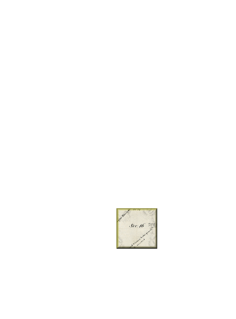
- 16/T31N,R14W
- 640-Acres
- Filing:
- Land Office:
- Patent:
- File No.
-
- Lars C Alstrom
-
- Nels and Martha Alstrom were born in Sweden; him in July 1851 and her in September 1854. They were married in 1884 and came to America together in that year. They apparently came directly to the island, since their homestead claim, on land that had previously been logged over by Nicholas Pickard, was filed in December of that same year, after his having worked as a hired hand for other island farmers. The following spring he built a log house on the property and moved in, the home being furnished with a stove, chairs, bed, and a table. During the next two years he acquired a plow, wagon, drag, hoe, and rakes. By the turn of the century he and Martha had produced a son and a daughter, and had six acres under cultivation, yielding potatoes, corn, rye, oats and turnips. They had also built a frame barn, which was home to four cows, two calves, two horses, two pigs, and two sheep. Shortly thereafter, about 1901, they sold the farm and left the island, apparently moving to Leland, probably because of health concerns. Nels died the following August.
Note: Attesting to the confusion over Scandinavian naming, Lars is variously referred to as Lars Christian Alstrom, Christian Alstrom, Lewis C Alstrom, Charles Alstrom, and Christian Olestrom.
-
- Andrew Anderson
-
- Andrew Anderson was a fisherman and bachelor farmer who had the distinction as having filed the first homestead claim on North Manitou Island. An immigrant from Norway/Sweden, he arrived on the island about 1870. Originally working as a commercial fisherman with two young Danes, Hendrick Frederickson and Fretz Paetsthow, he filed a homestead claim five years later for a parcel by the southwest tip of the island. On that property he cleared ten acres, logged five, built a small log house and a barn, and took up subsistence farming. He was already 53-years old at the time. A few years later he acquired another 40-acres on the other side of the island, not far from the Pickard dock and wharf. Not long thereafter he moved over to the mainland. He died in Kasson Township in 1903, still single at the age of eighty-one.
-
- John Andersen
-
- John Olaf Anderson was the son of Andrew Anderson. John came to America from Norway in 1882, a single young man of twenty-two years. In 1890 he married fifteen-year old Ildra Nerland, the daughter of island fisherman Mads Nerland, and filed a homestead claim for 160-acres immediately south of his father’s property near the Pickard dock on the island’s southeast side. He and his new wife settled on that property the same year, building a frame house and barn, cultivating a couple of acres, and giving birth to twelve children. After the turn of the century, when logging activities on the island provided better earnings opportunities than farming, like many others who gave up on farming in favor of a regular pay check, the Anderson’s moved their family to Crescent, the lumber “boom town” on the west side of the island. That activity lasted for about ten years, after which they moved back to the home that Mads Nerland had built, with John working as a hired hand, probably for the Bourniques, with the family also resuming subsistence farming on their own place. In later years some of the Anderson sons went to work for the Life Saving Service, others for the Manitou Island Association. Ildra and her daughter operated a boarding house for seasonal MIA workers. John and Ildra eventually left the island with their remaining children, taking up residence at Leland. John died there is 1935. Ildra lived another 16-years, passing away in San Diego, California just before Christmas in 1951.
- George Aylesworth (Aylsworth)
-
-
- George Aylsworth was born in 1819 at Clarence, New York, just west of Buffalo. He and Eliza Ann York were married in July of 1845, and they operated a farm there until moving their family to North Manitou Island to manage the wooding station business on the island’s west side. George had bought that business from Simon Pickard, probably about 1857. During fifteen years of successful operation, a village called Aylsworth developed at the site of the dock which in later years would become known as Crescent. In 1872 the family moved to a farm near present-day Empire, where George built a dock over which he sold thousands of cords of wood which the steamers used for fuel at that time. His operations consisted of bringing in 20 cords of "four-foot wood” a day during the winter months and 10 cords a day during the summer. Continuing in business at Empire for some 24-years, the family also operated a grist mill and hotel. Having lost his first wife, George married a second time at Detroit in June of 1868, wedding Margaretha, the daughter of John Johann Hutzler from South Manitou Island. George died in 1888. Maggie lived another 36-years, Both are buried in Empire’s Maple Grove Cemetery.
-
- Albert Bacon
-
- Albert W. Bacon was a young wheeler-and-dealer from Traverse City who was heavily involved in land speculation in the region. He acquired most of his holdings during the 1860s through the use of military bounty land warrants. These were certificates issued by the federal goverment, usually to soldiers, as payment in lieu of cash, which could be exchanged for any federally-owned land of their choosing. These certificates were frequently offered for sale at a fraction of their worth by the holder or their hiers, which provided opportunities for speculators to buy low, and sell high. Albert Bacon became very successful in the real estate business and other ventures around the Traverse City area. Being a young eligible bachelor with a flare also for social adventures, he became a celebrated bon vivant, at least to the extent that Traverse City ever had such a thing. Born in Vermont, he had come to the area as a twenty-five year old railroad surveyor in 1857. Within six years he had acquired vast holdings in the area, including all this property on North Manitou Island, and at that point he finally married ... but not to any of the hopefulls in Traverse. Less than a year later he died suddenly, a victim of a steamboat explosion at Detroit while traveling on business.
-
- John J Bagley
-
- John Judson Bagley’s acquisitions on North Manitou were probably purely philanthropic. He was neither a settler, nor a land speculator. A Michigan rages-to-riches story, his family moved to Michigan from New York State when he was eight years old, eventually settling at Owosso. At the age of fifteen, he went to Detroit to work as an apprentice in a small chewing tobacco shop. Seven years later he bought the store and became prominent in that business. At the age of 23 he was elected to the Detroit Board of Education. Going on to help found the Republican Party, he served as an alderman in Detroit, the Detroit Common Council, and the Detroit Board of Police Commissioners. He also helped to organize the Michigan Mutual Life Insurance Company and served as its president for five years, during which he concurrently served as chairman of the Michigan Republican Party. He was elected Governor of Michigan in 1872, serving two terms. He died in San Francisco at the age of 49, just four years after leaving office and was returned to Michigan for interment in Woodmere Cemetery at Detroit. Early in his very successful career Mr Bagley engaged in philanthropic interests, which probably explains his acquisition of these parcels. Under the 1862 Act referenced in most of his patents, Congress established a system of granting public lands to the states for the purpose of raising revenue to support the establishment of agricultural and mechanical colleges. The proceeds from the sale of these relatively useless parcels on North Manitou Island supported such initiatives in the states of Vermont and Connecticut.
-
- Fredric M Benham
-
- Frederic Marquand Benham was born in May of 1844 at Jackson, Michigan, his family progressively moving around the southern part of the state between there and Livonia Township north of Detroit. He enlisted in the Michigan 28th Infantry in March of 1865, serving briefly until his discharge that September. A nurseryman, he came to the island from Olivet, Michigan in 1881 with the intention of engaging in commercial fruit production. He filed a homestead claim for 160-acres in June of that year and, in association with Silas Boardman of Traverse City, launched his venture. In spite of having served less than six months, he always thereafter claimed to have a service related disability; namely "chronic diarrhea and piles," apparently working on the island from spring to fall, but spending the winter months with his younger brother at Olivet or in Petoskey, claiming that his homestead on the island was “not fit for residence during the winters for an invalid soldier.” He eventually acquired some 923-acres, cultivating orchards, vineyards and chestnuts. Unfortunately, in the late 1890s he lost it all. Having either become over-extended financially or, as one islander claimed, because shipping to the Chicago market had become so increasingly difficult and expensive as the steamships no longer routinely stopped at the islands, his property was seized by his creditors and sold in 1899 to the Newhall brothers, who owned a wholesale fruit business in Chicago. Frederic is thought to have died on the island in June of 1920. He had never married. At the time of his death he might actually have been living on South Manitou Island since, according to historian Leonard G Overmyer, author of Forest Haven Soldiers: The Civil War Veterans of Sleeping Bear & Surrounding Leelanau he was laid to rest in South Manitou’s Bay Cemetery.
-
- Alvar Bournique
-
- The Bourniques were among the island’s more colorful homesteaders. “Colonal” Bournique and his wife Mary operated a chain of formal dance academies in various locations from Chicago to Milwaukee which had been founded by his father the “noted dancing master” Augustus Eugene Bournique. They came to the island in 1903 as summer resorters, not as settlers. They filed a homestead claim in July of that year, and built a very unusual and picturesque “farm” on their 160-acre claim. Their main interest was in raising thoroughbred riding horses, and although they cultivated fields and maintained orchards on their farm, which eventually encompassed some 400-acres, it was more like a dude ranch than a place of agricultural production. Their rustic vertical log home was built with style, representing the best the island could offer, having seven bedrooms with dormers offering spectacular views, accessed via an open stairway from a large living room. A wood plank walk connected various out-buildings, including a two-story ice house in which ice above and below refrigerated milk and produce, and a large hewn log barn, the second story of which contained an elaborate ballroom-size dance floor. During the summer months they managed their operation by employing domestics and hired hands, the family usually in residence from May through September. Neighboring farm families were engaged as caretakers of the place during the winters. The Bourniques sold their dance schools and moved permanently to Leland in 1938. Alvar passed away there that same year. Mary continued to visit the place for a few more years before passing it on upon her death, in 1973 at 90-years of age, to her married daughter, who eventually sold it to the Manitou Island Association. Alvar and Mary McMunn Bournique rest in the company of many other North Manitou islanders in Leland’s Beechwood Cemetery.
Note: Lt. Col. Alvar Louis Bournique, served as Adjutant General of Company G, 128th Illinois Volunteer Infantry until being finally mustered out of the reserves in 1898. Mary McMunn Bournique was listed as a Daughter of the American Revolution as a descendant of Capt. Jonathan Stone.
-
- Nels Carlsen
-
- Nels and Sophia Carlson settled on North Manitou Island perhaps as early as 1878. They came from Sweden, Nels from a long line of fishermen in a sea coast village, and Sophia a skilled homemaker and excellent cook. They had come to America in 1877, and were married the following year. The first of their twelve children, William, came the following February. The Carlsons supported themselves on the island by farming and fishing, shipping farm products and barrels of salted fish to Chicago aboard the steamships that regularly stopped at the islands to take on wood. Nels and Silas Boardman also raised beef cattle for the Chicago market. Nels also served as a volunteer with the Life Saving Service, and later as a regular member of the crew. With so many children, it is not surprising that Nels and Sophia Carlson were also instrumental in the building of a schoolhouse on North Manitou, with Nels becoming director in 1895. As with so many other island families, the Carlsons found it increasingly difficult to make a living on the island as the old wood-burning steamboats turned into larger, coal-fired “propellers” and no longer stopped regularly at the Manitous. After some twenty-five years on North Manitou, they sold their place to the Newhall brothers. In March of 1903, they packed their belongings onto sleds and the remaining twelve-members of the family, along with their livestock, trekked across the ice to Leland. Two were left behind in the North Manitou Island cemetery; baby Elizabeth who died as an infant, and Nihilda, who passed away at twenty years of age. A new farm at Leland was more prosperous, and the family also became quite successful as commercial fishermen, creating the complex of fish shanties now known as Fishtown. Sophia lived until 1932, Nels following her in death three years later. Their graves can be found in Leland’s Beechwood Cemetery.
-
- Nickolas Feilen
-
- During the summer of 1893, Silas Boardman’s married daughter, Carrie Blossom, suggested that a resort community be developed on the island, and her father came up with the concept that led to what became known as Cottage Row, a string of ten summer homes along the low bluff facing the lake, just south of the Life Saving Station complex. The owners of these summer places were mainly couples who were friends of the Blossoms in Chicago, one being Mr. and Mrs. Howard W. Foote. Howard Foote engaged two skilled carpenters at Chicago to build their cottage on the island. According to an oral tradition, the Foote’s owned a music store in Chicago and had been exhibitors at the World’s Columbian Exposition in 1893, After the Fair closed, Foote supposedly salvaged materials as booths were dismantled, including fancy woodwork and stained glass windows, then shipped them to North Manitou for use in the construction of their cottage. One of the hired carpenters was Nicholas Feilen, who was born in Chicago, the son of Prussian immigrant carpenter Christave Feilen (or perhaps “Fealen”) and his wife Catharine. Nicholas’ work was apparently impressive enough that he was hired to build cottages and other structures by several others, which led to him calling upon his younger brother John, a skilled cabinet-maker, for assistance. Nicholas settled permanently on North Manitou, establishing a farmstead with a fine home next to the Bourniques at the island’s south end, supporting himself as a carpenter and farmer. He never married, and died on the Island in 1939 at the advanced age of 87.
Note: Although various other accounts suggest that both brothers were bachelors, John, also listed as an upholsterer, had actually been married to an English immigrant named Myra Bryers, and had a daughter aslo named “Myra,” but was divorced. In his old age he evidently came to the island and lived with his brother until Nicholas died. John died a year later on the mainland at Kasson Township. Both brothers were buried in the North Manitou Island cemetery, John being the last person to be buried there.
-
- Hendrik Fredriksen
-
- Some researchers claim that Henrik Frederiksen grew up on the Danish island of Laaland, the larger of several nearby islands and a place with forests and sand dunes. In view of the coincidences, that seems plausible. Single and 29-years of age, he was on North Manitou in August of 1870, living with two other Danes; Andrew Andersen (47) and Frederik (“Fretz”) Paetschow (25). Since Henrik’s father was Fredrik Andersen (hence the name Fredrik-sen (“Fredrik’s son”) it’s likely that Andrew was his uncle. Fretz Paetschow might have also been related by marriage, since it would appear that Henrik’s older brother Anders was on North Manitou with his family in 1880, living in the same household as two Paetschow families, his wife Johanna probably being a Paetschow. But if not originally related, they soon would be after Henrik Frederiksen married Fretz’s sister Lisette in 1880. These men were all fishermen. Henrik’s name eventually became Americanized to variations from “Hendrick Frederickson” to “Henry Fredrickson.” Although Hendrick originally bought a 68-acre plot from the government at the southeast end of the island between Pickard’s dock and Dimmick’s Point, he later bought a smaller parcel almost directly opposite on the west coast of the island, probably the 42.5-acres formerly patented to Albert W Bacon. There he built a home and a wharf of his own, and that is the place referred to as “Fredricksons” ever since. It would seem that these were men of the sea, rather than men who were interested in settling down anywhere on the land, since every subsequent census found them somewhere else; from North Manitou, to South Manitou, to Leland, to the Traverse Bay Peninsula, and even at Bailey’s Harbor, Wisconsin, a place with a natural harbor similar to South Manitou Island’s, and directly west across Lake Michigan from the Manitous. While they engaged in commercial fishing, which was probably their families’ primary means of livelihood, land-born family members probably engaged in small-scale subsistence farming. Hendrick and “Lise” (sometimes also called “Anne”) eventually settled at Bailey’s Harbor.
-
- Peter Hansen
-
- Peter Hansen, a Danish immigrant, lived here with his wife, son and two daughters, in a s small log cabin they’d built in 1877. While not much is known about the family, they evidently lived on the island for about a dozen years, having homesteaded this place and cultivated about nine of its 80-acres. They may have moved to the Glen Haven area on the mainland before 1900, where Peter became a mail carrier.
-
- Lyman Judson
-
- Lyman Parsons Judson was born Aug 1839 in a small farm community called Lafayette in Medina County, Ohio (south of Cleveland.) After growing up there, he and English-born Bithiah Howard were married in October of 1860; the Howards having arrived in America in 1850. They would have six children, only two of whom would survive into their adult years. A year after their marriage, Lyman enlisted in the military, seeing action in the Civil War with Ohio’s 2nd Calvary, serving as a farrier. After nine months of service, he was taken prisoner by Confederate forces at Lamar, Missouri. Five months later he was discharged with a partial disability. Six years later they moved with his family, and probably the Howards, to Benzie County, Michigan. They arrived at Frankfort on September 7, 1868 aboard the steamer Buffalo, Lyman’s father Silas eventually traveling to the Traverse City land office to purchase a 126-acre parcel not far south of Benzonia, just north of the Benzie River. Lyman spent most of his remaining adult life at Benzonia, serving as Postmaster and Benzonia County Treasurer. Bithiah lived until April of 1906. In April of 1929 Lyman was admitted to the Old Soldiers Home in Los Angeles, California. He died in June of 1932 and was returned to Benzonia where he was laid to rest next to his wife in the Judson family plot. Judson’s connection to North Manitou Island is not known. He was probably involved in land speculation, being employed as a “land looker” according to a report in an 1868 issue of the Traverse City Herald, appraising land in Antrim and Charlevoix Counties, but there is no record of his ever having been on North Manitou Island.
-
- John Maleske (Maleski)
-
- The Maleski family emigrated from Oswiecim (Auschuitz) in the Polish section of Prussia. They settled in Milwaukee, but Adam, probably about seventeen years old, is believed to have begun coming to North Manitou Island on a seasonal basis, working as a woodchopper for the wood yards that provided passing steamboats with fuel. He married Mary Leterske at Milwaukee in the early 1870s and soon thereafter they moved to the island. They had nine children, the last eight of whom were born on the island, including sons Paul (1884) and John (1886). The Maleskis supported themselves as commercial fishermen, by raising beef and pork, truck farming, and by growing and selling flowers. Perhaps because of their somewhat remote location at the northeast corner of the island, or because the older family members stuck to their native tongue rather than becoming fluent in English, the Maleskis were generally thought to be somewhat reclusive. John filed a homestead claim, taking over the property his family had traditionally used as the base for their commercial fishing activities. Paul took over the home place when his father died in 1922. Although the Bureau of Land Management has discovered no record of a claim for the 80-acres in Section 21 that was the original Maleski home place, the fact is well established by other resources. John attended Michigan State College in Lansing to learn about orchard management, courtesy of the Manitou Islands Association, and worked for MIA in that capacity while supplementing his income by continuing to fish commercially. He and his family left the island about 1929. Paul continued farming and fishing until abandoning the place and moving to Traverse City in 1940. The Maleskis have the distinction of being the family with the longest continuous presence on North Manitou Island, and the last of its independent farmers to leave as the island was taken over by the MIA syndicate.
Note: The patent issued for John Maleski by the government in 1919 misspelled his name as “Maleske”
-
- Reuben McCreary (or McCreery)
-
- The patent for this parcel, obtained using a military bounty land warrant from the War of 1812, was written in favor of “Reuben McCreary or McCrury” Apparently neither was correct. Historically, two men named Reuben McCreery came to Michigan from Erie County, New York. Both evidently settled in Genesee County, near the present day city of Flint, and both rose to some prominence. One was a lumberman, whose son William distinguished himself during the Civil War, rising from enlisted private to Lt. Colonel. After the war he was active in his father’s lumber businss, and later became a mayor of Flint, and Michigan State Treasurer. Presumably it is this “Reuben McCreery” who might have had an interest in North Manitou Island, although there is no record of any such individual ever being active there, beyond the securing of this claim.
-
- Niel McFadyen
-
- North Manitou’s earliest recorded landowner, was Neil McFadyen of Erie County, Pennsylvania. In 1848 he received patents from the government for two plotst; one immediately south of Pickard’s dock, and the other at Dimmick’s Point, about 45 acres in all. A sailor by trade, his family did not live on the island, but rather in the West Ward of Erie, Pennsylvania. He and his wife Christiana were both immigrants from Scotland. The McFadyens were both forty, and they had five children from age 12 to 8-months; Dugal, John, Neil, Catharine and Jenette, all born in Pennsylvania. Erie was an important port city, the only one on Lake Erie between Buffalo and Cleveland. The McFadyens probably lived close to the waterfront, since most all their neighbors were sailor’s families. Son Dugal remained in Erie, passing away there at the age of 68 in 1906. No other information about Neil and Christiana McFadyen has been discovered.
Note: “Niel” appears on the land patents, and is presumed to be a misspelling of Neil.
-
- Edwin H Munger
-
- Edwin Munger was a land speculator, who probably never set foot on either of the Manitou Islands, although he held property on both. His ancestry in America traces back to the arrival of English pilgrims in Connecticut in about 1639. The Mungers in America are said to have all descended from the boy Nathanial Munger, who was just ten or twelve years old when he arrived, coming perhaps involuntarily, since he was an apprentice to one of the men who immigrated that year. Edwin had the very good fortune of being close to a sister who married well, and whose husband was good enough to die unexpectedly at a very young age. His sister inherited her husbands business, Robert Hunter & Co., and elevated her brother Edwin, who had already been in her husband’s employ, to higher positions. Edwin went from being a canal boat operator on the Erie Canal’s Merchants’ Line to the head of his own Edwin H Munger & Co., a marine contracting firm that was involved in the building of the port facilities at the end of the canal, at Buffalo’s Erie Basin. Edwin Munger’s land acquisitions on the Manitou Islands were transacted between 1863 and 1865, all of it purchased using Military Bounty Land Warrants. His acquisitions were probably handled through agents called “land lookers.” As a person who was intimately involved in activities at the Lake Erie end of the Erie Canal, he would have been well familiar with steamboat operations, and the importance of the Manitou Islands as an essential fueling stop. With that in mind, his choice of land on North Manitou made perfect sense. It was mostly accessible wooded land along the island’s east Lake Michigan shoreline. Perhaps he intended that the stands of timber could be sold off, probably for much more than his cost for the land. And after that, he’d still have the land, which would likely be worth at least as much as he’d paid for the warrants. Whatever the plan, he would never live to see it realized. He died in the fall of 1867, and rests next to his wife Mary, and near his sister’s grave, in the Hunter family plot at Rochester, New York.
-
- Benjamin Newhall
-
- When the Fredrik Benham and Silas Boardman orchards venture began to struggle financially around the turn of the century, they were bought out by the Franklin Newhall, a fruit broker in Chicago who became known as the Apple King. His operations on the island were managed by his sons; Benjamin, who apparently handled planning and administration, and John, who was in charge of operations. They greatly increased the scope of their activities by expanding the acreage planted in apples, adding tart cherry and sweet cherry orchards, planting plums, pears and apricots, and other experimental varieties. During the new century’s first decade, Benjamin’s aggressive expansion strategies resulted in the Newhalls owning more than half the island’s land area, mostly on its east side. At that point they also began to promote the island as a resort, offering guest either hotel space or the use of a private cottage, with meals provided at their dining hall. Near the Coast Guard complex and the dock they built a post office and general store to serve their clients, who were typically twenty-somethings and younger from wealthy Chicago families. Further back, on the north side of the road from the dock, they built two fine cottages for themselves. Benjamin Newhall was, for the most part, and absentee manager, working out of his office in Chicago. This small 120-acre parcel was probably purchased from the government only to fill in a gap, they’re already having acquired the surrounding properties.
-
- John Newhall
-
- F. Newhall & Sons — Chicago, IL consisted of Franklin Newhall and his sons Simeon, Benjamin and Sylvan. Franklin came to Chicago in 1844, joining his brother Harrison’s existing business before establishing a similar business of his own. After being almost totally wiped out by the Great Chicago Fire in 1871, he started over, eventually becoming more successful than ever as a wholesaler located at Water Street, on the Chicago River next to the Michigan Avenue bridge. By the time of his ventures on North Manitou Island, around the turn of the century, Franklin had retired from the day-to-day operations of the business, his sons having taken it over. Benjamin originally represented the company on North Manitou Island, managing things there on a season basis until replaced by his son John, fresh out of Chicago’s Lewis Institute (which later became the Illinois Institute of Technology.) The island operations actually constituted only a small part of Newhall’s business. Franklin died in December of 1915. Unhappily, a year before that, and possibly arising from disagreements over the island operations, eldest son Simeon had attempted a take-over of the company by having his father declared incompetent. His brothers Benjamin and Sylvan remained loyal to their father who, at trial, proved to be not only bright, attentive and totally in charge of his faculties but also, at 92-years of age, warned his eldest son that he planned on living to 100. Although a court decided against the Simeon, after Franklin’s passing the brothers evidently began to shut down the business’ operations on North Manitou. In fact, he might have had good reason to do so, since by oral tradition, the Newhalls had run up against the same problem as previous ventures; the difficulty of arranging for shipment of ripe fruit on a timely basis, and the expense of doing so. John moved over to Thompsonville the mainland, managing company orchards there. After a stint as a car salesman in Manistee and still single, he returned to Glencoe, Illinois, the place where he’d grown up, finally taking a wife in 1928. He was 44, and his young wife Marion was 27. A year later daughter Nancy was born. Meanwhile, the Newhall properties on North Manitou were sold off to a group of Chicago businessmen organized as the Manitou Island Syndicate. They, in turn, sold out to a group from the Detroit area that came to be headed up by W.R. Angell and called the Manitou Island Association
-
- Nicholas Pickard
-
- Nicholas Pickard was born in Madison County, NY in 1817. He came to North Manitou in 1846 from Buffalo, NY where he was engaged as his uncle’s agent in supplying wood to the steamboats and established a station on the island to supply wood to the steamers sailing between Buffalo and Chicago. There were only two or three families on North Manitou at the time, and a wooding station on South Manitou. The original Pickard dock was on the island’s lower east side. After the 1847 season he sold his interest in the business Henry T Stringham and returned to Buffalo. Two years later he came back to North Manitou with his younger brother Simeon, engaging again in the wood business, this time on the island’s northeast side and operating a saw mill there. Simeon Pickard built a pier and established a wooding station on the island’s west side. Their families spent the summers with them on the island, returning to Buffalo during the winter months. Nicholas moved over to Leland in 1878 and built a pier on the mainland there, while still continuing his business on North Manitou. He had married Nancy Buss of Niagara County, NY in 1847, and they had eight children, only two of whom survived well into their adult years. Simeon sold out and left the island in 1857, moving first to Northport, then to Leland two years later. There he opened a general store and served in various civic roles, including Register of Deeds and Postmaster. He had married Almerine Beeman of Trumbull County, Ohio in 1854, and they had six children; four daughters and two sons. Nicholas Pickard died at Lebanon, Michigan in April of 1876, his wife Nancy then taking over the family’s business interests and expanding their holdings on North Manitou. Simeon died at Leland in May of 1899.
-
- Pickard & Stringham
-
- Nicholas Pickard and Joseph Stringham were briefly partners in the operation of a wooding station located on this site not later than 1846. Pickard sold out to Stringham in 1847 and returned briefly to buffalo, NY. He returned two years later with his brother Simeon, built docks on the northeast and west side of the island, built a saw mill on the northeast side, and a operated a farm.
-
- David Sawtell
-
- David Sawtelle was George Aylsworth’s brother-in-law. He was born in Scipio, New York in June of 1810, in the “finger lakes” region about 120-miles east of Buffalo. He married George’s older sister Mary in September of 1832. They had four children before Mary died, ten years later. A year after Mary’s death, David remarried Margaret Magoffin, and had two more children by her. The Sawtelle family lived in Williamsville, Erie County, New York, not far northeast of Buffalo. There is no record of them ever living on North Manitou Island, so presumably David’s interest there was merely an association with his brother-in-law. In Williamsville he was consistently listed as a hotel keeper, so perhaps that was his function on the island; operating a boarding house for his brother-in-law’s seasonal workers and other visitor.
Note: “Sawtelle” is the correct spelling of the name; which was evidently misspelled on the land patent.
-
- Joseph Stringham
-
- Joseph Stringham (1910-1900) was the brother of Henry T Stringham, both born at Santa Cruz in the Danish West Indies, and both one-time wood merchants. In the late 1830s Joseph was forced into bankruptcy by the failure of the Neshoto Lumber Co. of Twin Rivers, Wisconsin, a venture involving his brother and others. The messy matter was litigated for over 15-years, eventually winding up in the Wisconsin Supreme Court, during which time Joseph was generally considered penniless. He continued on, however, to become Treasurer of the State of New York, editor of the Buffalo Courier, a hotel owner, mayor, and citizen of note in Oshkosh, Wisconsin, and one of its wealthiest residents. He lived to age 90, passing away in February of 1900. Having never married, his remains were taken to Detroit for burial with other Stringham family members.
-
- Mary Swan
-
- Gustaf Olson Swan, an immigrant from Sweden, filed North Manitou Island’s second homestead claim in October of 1878. He and his wife Mary operated as subsistence farmers, having cleared only two of their 160-acres. Gustaf died in August of 1884, apparently of cancer, and Mary remained on the place only for another year, leaving it in October of 1885. The final proof of claim, filed the following year, was written in her favor, as widow of the original claimant. She lived in Leelanau County until the end of 1902, when she was admitted to the State Hospital at Traverse City (a.k.a. the Northern Michigan Asylum), where she died on June 6, 1907 at the age of 92-years.
-
- Daniel A VanValkenburgh
-
- “Van Valkenburg, Daniel A., was born in Canaan, Columbia county, N. Y., in 1810. His parents, Lambert and Freelove (Ellsworth) Van Valkenburg, moved to Erie county in 1830, settling at Tonawanda Creek, and it was there that Daniel began, in a small and limited way, the lumber business which afterwards, under his guidance, assumed such an important place in the history of Erie and Niagara counties, his logging camps and shipping yards being scattered through the western part of the State. His death, which occurred in 1873, was a loss not only to his family, but to his town and townspeople. Charitable and public spirited, his hand was ever ready to aid any enterprise intended to benefit his fellowmen. No religious or educational institution appealed to him in vain, and although living an intensely active life, he was always willing to lay aside his own affairs to take up and further any plan for the benefit of his city or his associates.”
From “Landmarks of Niagara County, New York” published in 1897.
Van Valkenburgh’s interests on North Manitou were probably also lumber-related. There is no record of his ever having visited the island, or being personally active there. He held other land patents in Michigan, in Oscoda and Iosco counties on Lake Huron.
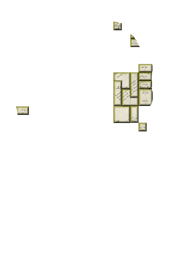
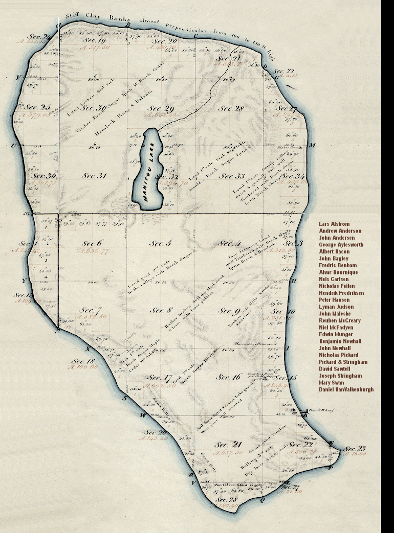
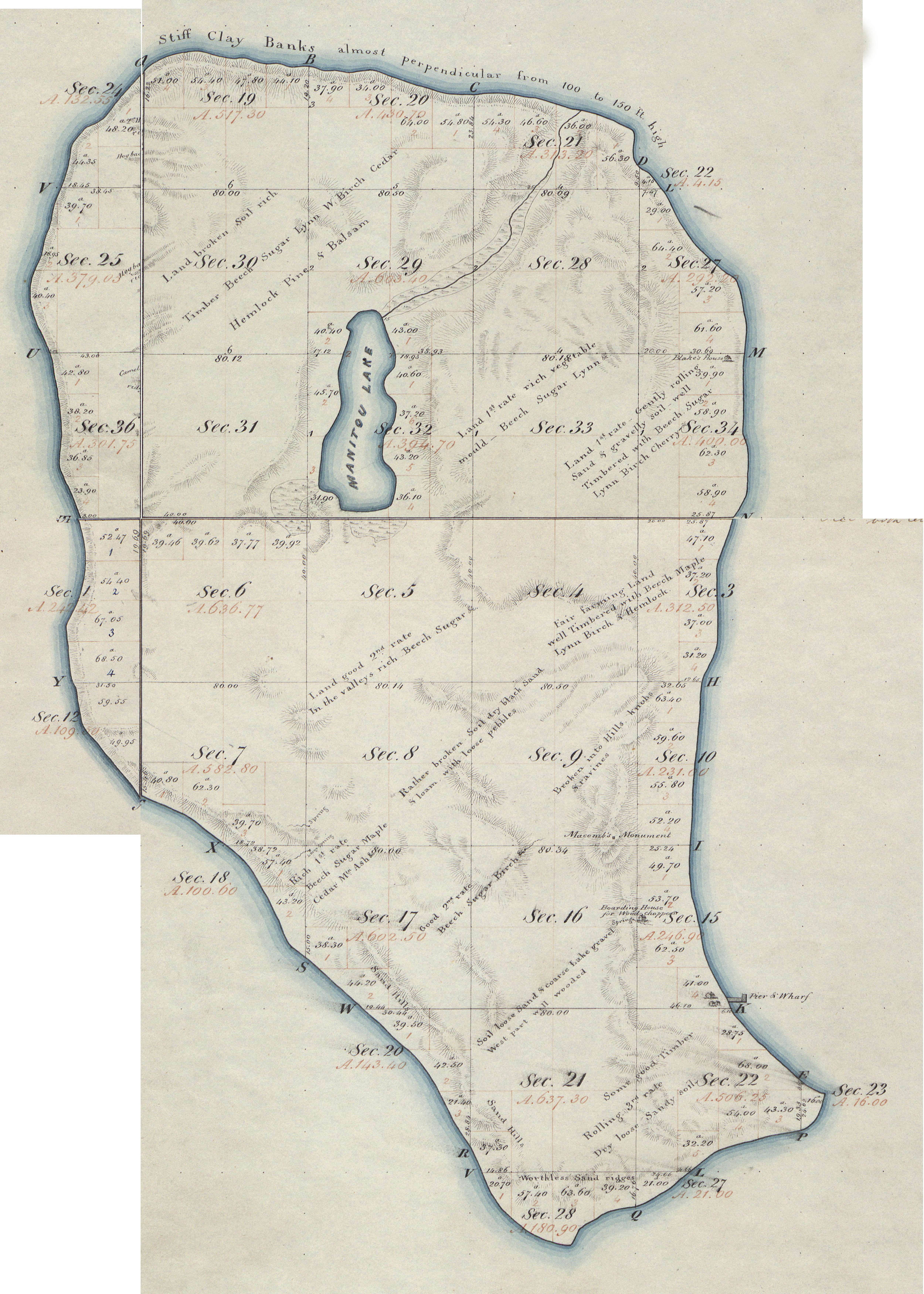
Back | Click map to enable plot selection mode | Reset to restore mouse-over browsing | view map detail
Footnotes:
(1) Mouse over map to identify plots. Click on patentee name to display all his holdings.
(2) The land office at Duncan was open from 1854 to 1858. Duncan is a township in Houghton County in Michigan’s Upper Peninsula.
(3) The Scrip/Warrant Acts of March 3, 1855 (10 stat. 701) and March 18, 1842 (5 stat. 607) authorized the issuance of scrip as payment
for military or other service. This scrip could be used to purchase federal land. These documents were transferable and often sold for
cash by the veteran, his widow or heirs. Homestead applications were authorized by the Homestead Act of May 20, 1862 (12 Stat. 392).
Sales of public lands for cash were authorized by the Cash Entry Act of April 24,1820 (3 stat. 566). An act of the 55th Congress
(30 Stat. 993) authorizing certain forest reserves provided that any settlers on lands set aside could relinquish their rights thereto and
and take other public lands in lieu thereof. The Taylor Grazing Act of June 28, 1934 (48 Stat. 1269) authorized exchanges of public lands
for lands designated by the Secretary of the Interior as necessary to certain purposes essential to the well-being of the nation.
(4) Examples, read ...
“NW-9/T31N,R15W” as the NorthWest quarter of Section 9 in Town 31-North, Range 15-West.
“W½SW-3/T31N,R15W” as the West half of the SouthWest quarter of Section 3 ...
“NWNW-35/T31N,R15W” as tje NorthWest quarter of the NorthWest quarter of Section 35 ...
“4-10/T31N,R15W” as Lot 4 in Section 10 ...
All coordinates given with reference to the Michigan-Toledo Strip; Leelanau County, Michigan.
For more information, see Public Land Survey System (PLSS) Tutorial from Wisconsin’s DNR
(5) Information provided by the Bureau of Land Management, General Land Office Records, including this map of the 1847 Orange Risdon Survey.
© 2011, ManitouIslandsArichivs.Org, All rights reserved.


