Original Land Ownership - South Mantiou Island
- Chris Ankerson
- Sale-Cash Entry
- 2-35/T31N,R15W
- 31.2-Acres
- Filing: Jan 23, 1882
- Land Office: Reed City
- Patent: Jan 7, 1885
- File No. MI2950__.349
- Thomas Armstrong
- Homestead Entry
- W½NW-3/T30N,R15W; W½SW-3/T30N,R15W
- 160-Acres
- Filing: May 2, 1868
- Land Office: Traverse City
- Patent: Feb 1, 1875
- File No. MI2500__.359
- Albert W Bacon
- Scrip/Warrant
- N½SE-8/T30N,R15W; 2-8/T30N,R15W
- 123.78-Acres
- Filing: Nov 15, 1862
- Land Office: Traverse City
- Patent: Mar 16, 1863
- File No. MW-0142-199
- Albert W Bacon
- Scrip/Warrant
- 3-9/T30N,R15W; 4-9/T30N,R15W; SWNW-10/T30N,R15W; 4-10/T30N,R15W
- 173-Acres
- Filing: Nov 15, 1862
- Land Office: Traverse City
- Patent: Mar 16, 1863
- File No. MW-0142-200
- August Beck
- Homestead Entry
- S½SE-32/T31N,R15W
- 80-Acres
- Filing: Jul 26, 1903
- Land Office: Marquette
- Patent: Jun 17, 1909
- File No. 67666
- Christoph Beck
- Homestead Entry
- SW-33/T31N,R15W
- 160-Acres
- Filing: Feb 25, 1863
- Land Office: Traverse City
- Patent: Nov 1, 1869
- File No. MI2470__.218
- Putnam Burdick
- Scrip/Warrant
- Frac26/T31N,R15W; 1-27/T31N,R15W; 4-35/T31N,R15W; NWNW-35/T31N,R15W
- 125.3-Acres
- Filing: Dec 7, 1861
- Land Office: Traverse City
- Patent: Mar 1, 1862
- File No. MW-0142-051
- Putnam Burdick
- Scrip/Warrant
- 2-27/T31N,R15W; 3-27/T31N,R15W; 4-27/T31N,R15W;
- 133.1-Acres
- Filing: Nov 19, 1862
- Land Office: Traverse City
- Patent: Mar 16, 1863
- File No. MW-0142-203
- Putnam Burdick
- Scrip/Warrant
- S½SE-28/T31N,R15W; SESW-28/T31N,R15W
- 120-Acres
- Filing: Nov 19, 1862
- Land Office: Traverse City
- Patent: Mar 16, 1863
- File No. MW-0142-206
- Putnam Burdick
- Scrip/Warrant
- E½NE-32/T31N,R15W; NESE-32/T31N,R15W
- 120-Acres
- Filing: Nov 19, 1862
- Land Office: Traverse City
- Patent: Mar 16, 1863
- File No. MW-0142-204
- Putnam Burdick
- Scrip/Warrant
- NE-8/T30N,R15W
- 160-Acres
- Filing: Oct 28, 1862
- Land Office: Traverse City
- Patent: Mar 16, 1863
- File No. MW-0142-179
- Putnam Burdick
- Scrip/Warrant
- SE-5/T30N,R15W
- 160-Acres
- Filing: Oct 28, 1862
- Land Office: Traverse City
- Patent: Mar 16, 1863
- File No. MW-0142-202
- Putnam Burdick
- Scrip/Warrant
- W½NW-9/T30N,R15W; W½SW-4/T30N,R15W
- 160-Acres
- Filing: Oct 28, 1862
- Land Office: Traverse City
- Patent: Mar 16, 1863
- File No. MW-0142-205
- Putnam Burdick
- Scrip/Warrant
- NE-5/T30N,R15W
- 160-Acres
- Filing: Nov 19, 1862
- Land Office: Traverse City
- Patent: Mar 16, 1863
- File No. MW-0142-201
- Putnam Burdick
- Sale-Cash Entry
- S½NE-34/T31N,R15W
- 80-Acres
- Filing: Sep 29, 1864
- Land Office: Traverse City
- Patent: Jul 10, 1865
- File No. MI2400__.262
- Putnam Burdick
- Sale-Cash Entry
- 2-9/T30N,R15W
- 45.3-Acres
- Filing: Aug 29, 1864
- Land Office: Traverse City
- Patent: Jul 10, 1865
- File No. MI2400__.263
- William Burton
- Sale-Cash Entry
- 1-34/T31N,R15W
- 56.85-Acres
- Filing: Nov 8, 1849
- Land Office: Sault Ste. Marie
- Patent: Dec 1, 1851
- File No. MI1960__.277
- William Burton
- Sale-Cash Entry
- 1-3/T30N,R15W; 2-3/T30N,R15W
- 104.3-Acres
- Filing: Nov 8, 1849
- Land Office: Sault Ste. Marie
- Patent: Dec 1, 1851
- File No. MI1960__.282
- William Burton
- Sale-Cash Entry
- 2-34/T31N,R15W
- 24.75-Acres
- Filing: Nov 8, 1849
- Land Office: Sault Ste. Marie
- Patent: Dec 1, 1851
- File No. MI1960__.283
- William Burton
- Sale-Cash Entry
- 3-3/T30N,R15W; 4-3/T30N,R15W
- 112.04-Acres
- Filing: Nov 8, 1849
- Land Office: Sault Ste. Marie
- Patent: Dec 1, 1851
- File No. MI1960__.284
- William Burton
- Sale-Cash Entry
- NWSW-9/T30N,R15W
- 40-Acres
- Filing: -
- Land Office: Sault Ste. Marie
- Patent: Feb 10, 1854
- File No. MI1980__.173
- William Burton
- Sale-Cash Entry
- 5-9/T30N,R15W; 6-9/T30N,R15W; 7-9/T30N,R15W; 8-9/T30N,R15W
- 179.1-Acres
- Filing: Oct 7, 1853
- Land Office: Sault Ste. Marie
- Patent: May 1, 1855
- File No. MW-1116-293
- Andrew Erickson
- Homestead Entry
- 1-28/T31N,R15W; 2-28/T31N,R15W; 3-28/T31N,R15W
- 129.7-Acres
- Filing: Aug 23, 1890
- Land Office: Grayling
- Patent: Jan 26, 1898
- File No. MI3110__.490
- Charles F L Erickson
- Sale-Cash Entry
- 3-35/T31N,R15W
- 43.3-Acres
- Filing: -
- Land Office: Marquette
- Patent: Feb 9, 1914
- File No. 383777
- Alfred T Evans
- Homestead Entry
- NE-4/T30N,R15W
- 160-Acres
- Filing: Jly 11, 1863
- Land Office: Traverse City
- Patent: Oct 1, 1870
- File No. MI2470__.459
- George Haas
- Homestead Entry
- NW-33/T31N,R15W
- 160-Acres
- Filing: Feb 25, 1863
- Land Office: Traverse City
- Patent: Sep 10, 1870
- File No. MI2470__.425
- Joseph Haas
- Homestead Entry
- 1-10/T30N,R15W-Less 10.15 Acres In Lot 1 For Lighthouse; 2-10/T30N,R15W; 3-10/T30N,R15W
- 137.5-Acres
- Filing: Mar 19, 1883 (rev Nov 16, 1898)
- Land Office: Grayling
- Patent: Dec 27, 1898
- File No. MI1070__.250
- George Conrad Hutzler
- Homestead Entry
- NW-4/T30N,R15W
- 160-Acres
- Filing: Apl 20, 1868
- Land Office: Traverse City
- Patent: Feb 10, 1874
- File No. MI1070__.250
- George Johann Hutzler
- Sale-Cash Entry
- W½NW-34/T31N,R15W
- 80-Acres
- Filing: -
- Land Office: Traverse City
- Patent: Nov 1, 1864
- File No. MI2400__.051
- George Johann Hutzler
- Sale-Cash Entry
- E½NW-34/T31N,R15W
- 80-Acres
- Filing: -
- Land Office: Traverse City
- Patent: Jul 10, 1865
- File No. MI2400__.254
- George Johann Hutzler
- Homestead Entry
- NE-33/T31N,R15W
- 160-Acres
- Filing: Jan 9, 1863
- Land Office: Traverse City
- Patent: Nov 1, 1869
- File No. MI2470__.219
- George Hutzler
- Sale-Cash Entry
- SWNW-8/T30N,R15W; 1-8/T30N,R15W
- 95.5-Acres
- Filing: Apl 26, 1900
- Land Office: Marquette
- Patent: Feb 16, 1905
- File No. MI3310__.113
- Ray Kent
- Homestead Entry
- N½NE-34/T31N,R15W
- 80-Acres
- Filing: Jan 24, 1915
- Land Office: Marquette
- Patent: Dec 31, 1923
- File No. 927951
- Thomas (Mary) Kitchen
- Homestead Entry
- SE-33/T31N,R15W
- 160-Acres
- Filing: Jan 31, 1862
- Land Office: Traverse City
- Patent: Nov 1, 1869
- File No. MI2470__.148
- Richard Kitchen
- Homestead Entry
- SW-34/T31N,R15W
- 160-Acres
- Filing: Apr 29, 1863
- Land Office: Traverse City
- Patent: Nov 1, 1869
- File No. MI2470__.217
- Michigan Dept of Conservation
- Exchange-Natl Forest
- E½E½-7/T31N,R15W; NWNW-8/T31N,R15W; 4-28/T31N,R15W; 1-29/T31N,R15W; 1,2,3 & 4-32/T31N,R15W
- 68.8 of 278.51 Total Acres
- Filing: -
- Land Office: Washington, D.C.
- Patent: Jan 15, 1958
- File No. 1178709
- Michigan Dept of Conservation
- Exchange-Natl Forest
- E½E½-7/T31N,R15W; NWNW-8/T31N,R15W; 4-28/T31N,R15W; 1-29/T31N,R15W; 1,2,3 & 4-32/T31N,R15W
- 158.2 of 278.51 Total Acres
- Filing: -
- Land Office: Washington, D.C.
- Patent: Jan 15, 1958
- File No. 1178709
- Michigan Dept of Conservation
- Exchange-State Taylor Act
- W½SW-5/T30N,R15W; 2-5/T30N,R15W; 6/T30N,R15W
- 205.65-Acres
- Filing: -
- Land Office: Washington, D.C.
- Patent: Jun 15, 1961
- File No. 1220526
- James Miller
- Homestead Entry
- 1-9/T30N,R15W; N½NW-10/T30N,R15W
- 128.25-Acres
- Filing: Feb 20, 1875
- Land Office: Reed City
- Patent: Mar 10, 1883
- File No. MI3070__.198
- Edwin H Munger
- Scrip/Warrant
- E½SW-5/T30N,R15W; E½NW-8/T30N,R15W
- 160-Acres
- Filing: Nov 3, 1864
- Land Office: Traverse City
- Patent: Jan 20, 1872
- File No. MW-0550-048
- Nels Nelson
- Sale-Cash Entry
- 1-35/T31N,R15W
- 34.5-Acres
- Filing: -
- Land Office: Marquette
- Patent: Feb 12, 1914
- File No. 384743
- Peter Nenno
- Sale-Cash Entry
- 11/T30N,R15W
- 4.7-Acres
- Filing: Oct 11, 1862
- Land Office: Traverse City
- Patent: May 15, 1863
- File No. MI2390__.486
- Rolland Shank
- Homestead Entry
- 1-5/T30N,R15W; SENW-5/T30N,R15W
- 90.06-Acres
- Filing: Aug 14, 1903
- Land Office: Marquette
- Patent: Feb 2, 1911
- File No. 176464
- Aaron A Sheridan
- Sale-Cash Entry
- E½SW-4/T30N,R15W
- 80-Acres
- Filing: Apl 2, 1868
- Land Office: Traverse City
- Patent: Jul 1, 1869
- File No. MI2420__.368
- James Sheridan
- Homestead Entry
- 1-4/T30N,R15W; 2-4/T30N,R15W; 3-4/T30N,R15W; 4-4/T30N,R15W
- 130.2-Acres
- Filing: Apl 21, 1868
- Land Office: Traverse City
- Patent: Sep 14, 1874
- File No. MI2500__.135
- Chris Ankerson
-
- Christen Anchersen Kragelund was born in 1846 at small farming village on Denmark’s Jutland Peninsula. In March of 1872, at the age of 25, he left Denmark aboard the America-bound ship Franklin, arriving at New York in May. He arrived at the island sometime prior to 1878 and he became one of the island’s commercial fishermen. That is known because of his having been the only survivor of the tragedy that took the lives of lightkeepers Aaron and Julia Sheridan, and their young son Robert in March of that year. Two years after that, he returned to Denmark to find the girl he’d left behind. There he married Nielsena Thomasen, known to most as Sine, and in early April the newlyweds sailed from Copenhagen aboard the America-bound three-masted propeller Thingvalla. Their honeymoon voyage turned into an ordeal when the ship developed mechanical problems, spending the month drifting helplessly among the icebergs in the North Atlantic. They finally arrived at South Manitou in June. The Ankersons owned a single plot of 31.2 acres, at what became known as “Gull Point.” There, during the next dozen years, Chris continued his trade as a very successful commercial fisherman, and Sine gave birth to three children. They were a popular family who were engaged socially and civically on the Island until about 1892, when they moved to Dannebrog, Nebraska, Nebraska’s Danish Capital. There Sine gave birth to her last child, a son. The Ankersons then returned, settling on a farm on Long Lake Road not far west of Traverse City. Chris resumed his occupation in commercial fishing, working by himself on and off at South Manitou Island, while the rest of the family and a hired man worked the farm.
- Thomas Armstrong
-
- Thomas and Margaret Armstrong homesteaded 160 acres in a plot that parallels the east side of Ohio Road, between Burdick Road and Chicago Road. They were a young couple from Castlebar in County Mayo, Ireland, arriving on the island around 1864 after having lived in New York State for at least since 1861. They came with three children, built a 1-1/2 story log home, evidently on the north end of their claim, and had six more children here. During their time here, they farmed about fifteen acres and logged ten, leaving the remainder undeveloped. Besides the usual crops of oats, rye and potatoes, the farm included and orchard, currant bushes and a strawberry patch. Livestock included milk cows, beef cattle, sheep and pigs. Two of the Armstrong sons became lightkeepers on the island; James in 1885 (who had married Jessie Kitchen) and Thomas Jr in 1890. After upwards of twenty-six years on the island, farming and raising their large family there, in December of 1890 Thomas and Margaret sold their property to the Garden City Sand Company, which was eagerly buying up real estate with the idea of turning the island into a resort. They moved to Washington Avenue in Traverse City with their two youngest daughters, where they spent the rest of their lives. Thomas died twenty years later at age 81, Margaret following five years later at 76 years of age.
- Albert W Bacon
-
- Albert W. Bacon came to Traverse City in the spring of 1857, when he was twenty-five years old. He came as a young surveyor working for the Grand Rapids and Indiana Railroad. His ancestry was English, his family’s presence in America dating back to the mid-1600s, originating at Barnstable, on Cape Cod, with the Massachusetts colony. Albert was born in Vermont, coming into the world on May 19, 1832. As young bachelor, he originally made his home in Traverse City, at a boarding house on Front Street. It wasn’t long before he had made a name for himself as a land speculator, and within six years, he had acquired approximately half of North Manitou Island, 297-acres on South Manitou Island, all of Marion Island in Grand Traverse Bay, and a variety of property in and around Traverse City. Most of Albert Bacon’s acquisitions, upwards of 90% of them, were military bounty land warrant transactions. His success in real estate brought a degree of prominence in the area, leading to other ventures in business and public service. He finally married in the fall of 1863. Unfortunately, at the peak of his success, he was killed the following spring when the steamboat Nile blew up at its Detroit dock while making ready to depart for its scheduled voyage to Chicago. Albert’s cousin, the respected Probate Judge Daniel Stanton Bacon of Monroe, spent the next two years as a frequent visitor at Traverse City, helping the unfortunate widow settle her late husband’s affairs.
- August Beck
-
- August was the youngest of three Beck brothers who came to America from Cattenstat, Germany. Accounts vary, but brothers Theodor and Albert apparently came to the island first at the invitation of Christoph Beck, followed around 1870 by their parents and young brother August, who was then about 17-years old. At the time he filed a claim for this property, August was about 56-years old and already well established on the 160-acre farm originally patented to Christoph Beck some 40-years before. Thus, this property was probably never actually homesteaded, but rather used for logging, pasturing livestock and orchards with peaches and apples, as an adjunct to the main Beck farm which, today, is generally, but incorrectly, referred to as “the August Beck farm.”
Note: As a matter of policy, the National Park Service ordinarily names places according to their original owner or settler, which in this case would have been Christoph Beck.)
- Christoph Beck
-
- Christoph and Catharine Beck were the first of the Beck family to settle on the island, arriving sometime after July of 1860 and before February of 1863, when Christoph filed a homestead claim for 160-acres. They would be followed by the brothers Theodor and Albert, then by the boys’ parents David and Dorothea and their youngest brother August. Christoph was about ten years younger than David Beck, so the two might have been brothers. Although their relationship has thus far not been established, they all came from Cattenstat, Germany and all of the Becks who followed Christoph and Catharine wound up living and working on their 160-acre homestead. Christoph and Catharine evidently never had children of their own. Although it was Theodor and Albert who originally worked the farm with Christoph and Catharine, ten years after the arrival of their parents and younger brother, August had taken over half the 160-acre farm, with Christoph and Catharine on the other half. Theodor and Albert were elsewhere, on a 160-acre farm which was listed as the island’s most prosperous and productive. If the order in which the census taker entered his data is any indication, this farm may have been on the south side of the island, next along the road after the James Miller place. At that time, William Burton owned all the property later identified as the Theodor Beck farm, and according to letters written by his wife Lucy Burton, they also lived there, along with “a family who operated the farm.” George Johnson also mentions that the Becks lived in log cabins there “before moving into the big house” after eventually acquiring the place, presumably in the 1890s when the Burtons finally all left the island.
- Putnam Burdick
-
- Putnam Burdick was by far the island’s biggest land-owner. He and his wife Melissa came to the island in the early 1850’s with their four children; Almira, Jane, Andrew and George. They came from the town of Erin, in Macomb County, where they had operated a boarding house, possibly with the intention of managing a similar operation for the Burtons. The Burdicks traced their ancestry in America back some 200-years, coming from England, but probably of German descent. Putnam and the noted lightkeeper Dr. Alonzo J. Slyfield were close friends, which might also have had something to do with their coming to the island. Slyfield took the job of lightkeeper on South Manitou after illness forced him to give up his medical practice in Macomb County. Putnam and Melissa had two more children after coming to the island: Frank in 1853 and Fanny in 1859. According to a note in an old family bible, Putnam was “a ship fueler and farmer” which suggests that he was probably working for the Burtons most of the time, possibly in a supervisory capacity, rather than as a laborer. During their time on the island, Putnam apparently never did much significant farming, but managed to acquire some 1,263 acres, almost 1/4th of the entire island, most of which was purchased using military bounty land warrants. Through the family’s connection with the Slyfields no doubt, two of the Burdick sons became lightkeepers. Although no actual death record has ever been located, Putnam apparently died in 1875, and was buried in the Mount Hazel Cemetery, near Redford in Wayne County. Melissa then left the island, moving to a farm near Glen Arbor with remainder of her family. She died there ten years later.
- William Burton
-
- William Burton was first to establish a presence on the island, coming not as an immigrant settler, but as the Manitou Passage’s first entrepreneur. The Burtons had been in America since the early 1600s, as had the family of his wife Lucy Boyd Rice, both families having become very well connected. The Burtons came to the island from Ohio City (now Cleveland), probably as a partnership called Burton, Lord & Co. involving William Burton, his brother Hubbard Blackman Burton, and Richard Lord, a major share-holder in the Cuyahoga Steam Furnace Company which, among other things, manufactured steamboats, its first, the Empire launched in 1844. Hubbard was a ships captain, regularly sailing the Manitou Passage, so was likely the source of the idea. They came to the island in 1836, and after the operation was organized on the island, William Burton managed it, probably commuting frequently, while Richard Lord remained involved in his interests in Cleveland and Hubbard Burton continued sailing. Within a few years the Burton, Lord & Co. wood yard on South Manitou Island had developed into the largest and most successful wooding station on the Great Lakes, and thus also the largest employer. Besides wood choppers and dock hands, “Burtons Wharf”, as it came to be known, included a blacksmith shop, general store, a boarding house, and a small community of simple residences. By 1850, Burton had brought his sons Ellison E Burton and James Covel Burton into the business, with the three families resident on the island, at least during the shipping season. In later years, Ellison took over the business, with William retiring to a farm with a fine home on the island’s south side, probably to what is today called the Lodge.
- Andrew Erickson
-
- Andrew Erickson started out fishing off on North Manitou, then brought his wife Ulrica and their children to south. The Ericksons, who were originally from Sweden, arrived on South Manitou around 1882. He was primarily a commercial fisherman. Their son Leonard eventually took over their place, while their daughter Selma, who was born in Stockholm, married George Isaac Hutzler, the Buffalo-born son of Johann Hutzler.
- Charles F L Erickson
-
- Charles Erickson has not yet been identified. In view of the location of this claim, it seems likely that he might have been a commercial fisherman, perhaps living on the Michigan mainland, or in Wisconsin.
- Alfred T Evans
-
- Alfred Evans arrived on the island in about 1863 with his two children Albert (4) and Fanny (1), plus his new wife Hannah and her two sons from her previous marriage, Thomas (6) and William (4) Foster. Alfred and Hannah were both recent English immigrants (Hannah in 1854), having both been recently widowed, Hannah also having recently lost her youngest son, Henry. Although they came to the island from Milwaukee, the boys Thomas and William Foster had been born on the island. Unfortunately, Alfred died shortly after receiving the patent for his homestead claim, leaving Hannah and the children to run the farm, along with a hired hand. William eventually went off into the world, educated himself in the legal profession, became a lawyer in Traverse City and was elected to the State Legislature. Hannah moved to Traverse City and supported herself by running a boarding house. Thomas married Estella Raimau, older sister of Florence Raimau Haas, and his family remained on the farm. Besides farming, they operated a sawmill on the property, and Thomas served a Postmaster from October of 1889 until August of 1907. About that time he and his remaining family gave up the farm and moved off the island to Traverse City to care for his aging mother.
- George Henry Haas
-
- George and Maria Haas arrived on the island with their children Joseph, John and Elizabeth about 1860 and settled on this farm. They built a large house here, which was not far from the Johann Hutzler place, and the families remained close friends for many years. Two more sons were born here; Henry and William. Henry eventually married the Hutzler’s daughter Maggie. George and Maria Haas were buried in an orchard on this farm; their graves having been discovered by the National Park Service and enclosed within a picket fence. John married and, with his brother Bill, took over the home place. John’s wife and only child died of some illness, and he never remarried, remaining on the farm with his brother Bill for the rest of their lives, Bill doing most of the field work, while John cared for the livestock and did the cooking. Bill also served as the island’s blacksmith, until his shed burned down, destroying all his tools and equipment. The Haas brothers typically pressed enough apples from their orchard each year to produce two 55-gallon barrels of hard cider, naturally fermented with sugar and raisins. John died in 1924, and shortly thereafter the large house was struck by lightning and burned. Islanders helped Bill, then 65 and bent with age, construct a one-room log cabin here, where he lived out his remaining years and which was eventually all that remained of the Haas farmstead.
- Joseph Haas
-
- Joseph Haas was the second-eldest son of George and Maria Haas, all of who emigrated from Bavaria. Landing first in Buffalo, New York, the Haases came to the island about 1860, when Joseph was about 7-years old. At age twenty-six, he married 16-year old Florence Raimau, his embittered mother thereafter seeing to it that her son Joseph and his French-English wife were written out of the will. When George Haas died, the estate was divided among the other brothers, Joseph receiving just one dollar. Florence, however, proved to be an intelligent and energetic woman. She and Joseph had three children; Isaac (George), Jessie, and Lawrence Haas. Besides having these three, Florence became the island’s de facto midwife, helping bring many other island children into the world. Joseph became a farmer and the island’s mail boat operator, but drowned in the bay on June of 1912 near the Coast Guard dock. Florence then took over the service. According to George Johnson, what the National Park calls the Johnson House, which still exists on this property, was built by Lawrence in 1903, partly out of materials salvaged from the wreck of the Robert L Frost. Florence and her son Lawrence left the island in 1913, he moving to Empire and she to Frankfort and a new career, sailing as part of the crew on a Lake Michigan carferry. Lawrence married four years later and returned to the island. Florence later moved to Houston, Texas, where she became rather wealthy as a result of successful real estate ventures.
- George Conrad Hutzler
-
- Conrad Hutzler, by oral tradition, came to America at the urging of his older half-brother Johann. Conrad showed up on the island sometime during the 1860s, having apparently come by way of Buffalo, New York. Not much is definitively known about the origins of Conrad Hutzler. From the resources that are available, it would appear that he might have been working as a crewman on a ship, as had his brother before him. He was apparently unmarried, until meeting Christina Shank, probably a widow from Erie, Pennsylvania, that being a nearby port on Lake Erie, perhaps the first stop out of Buffalo. She had two children by her previous marriage, Roland (b. abt 1858) and Mary Ann (b. abt 1862). Given the time frame, it would be quite possible that her first husband was a casualty of the Civil War. She and Conrad Hutzler were probably married about 1865, since their first child Catharine, according to the 1870 census, was born in New York before August of 1866. Their second child, Margaret (“Maggie” Hutzler) was born on the island before August of 1969. Since Conrad filed his island homestead claim in April of 1868, the assumption is that they arrived on the island during the year 1867. Their third and last child was George Conrad Hutzler Jr., born on the island in October of 1872. He married “Josie” (Josephine), daughter of August Beck, and together with their only son Lewis, became notable in the annals of agronomy for the development of Rosen Rye. Christina is thought to have died in 1883, and Conrad 13-years later. He was laid to rest on a hill overlooking their farm.
Note: The 1880 census contains enough error as to be considered factually unreliable.
- George Johann Hutzler
-
- George Johann and Margaretha Hutzler emigrated from Bavaria, arriving in Buffalo, New York in 1854 after a harrowing 3-months voyage on the crippled bark Sir Isaac Newton, during which they lost their youngest son. Johann found work aboard the steamboat Iowa, sailing between Buffalo and Chicago, and regularly stopping for cord wood at South Manitou Island. Deciding that the island offered a better place for his family, he left the boat and took a job working here for William Burton, bringing his wife and two children, Anna and George Isaac, to the island about a years later. Four more children were born here; Catharine, John, Ludwig and Louisa. Johann Hutzler filed claims for some 320-acres, and it would appear that this was divided into two 160-acre farms. Son George married Selma Erickson, his family apparently taking over the east 160-acres. After George died in 1909, Selma and her children remained on the farm until it was taken over by daughter Lottie and her husband John Tobin. Selma then moved to the village area, where she operated a store with her brother Leonard until her passing, some 12-years later. Johnny Hutzler married Bertha Peth and took over the home place, with his wife and widowed mother. After the death of their only child, young son Stanley, John and Bertha were divorced. Bertha moved to the village area, while Johnny remained on the farm and living alone until his death in 1944. George Johann Hutzler died in 1884 at the age of seventy and was buried in the orchard at this farm. Margaretha died 25-years later (1909) while living in Chicago with one of her daughters.
- George Conrad Hutzler Jr.
-
- George Hutzler, as he was always known, was the son of Conrad Hutzler. He married Josephine (“Josie”) Beck, daughter of August Beck and Elizabeth Haas, and they had one son, Lewis. Josie died rather young, in 1911, at just 35-years of age. After her death, George and Lewis remained on the farm, eventually becoming involved with the Michigan Crop Improvement Association and Michigan State College in agricultural seed development projects, including Rosen Rye and the Michelite Bean, both of which became common, high yield money crops. Lewis married in 1922, and his wife Lola (a rotund and unattractive woman said to be a mail-order bride) became actively involved with the running of the farm, the couple remaining there until George died in 1944, then selling the place to William Boales in 1946 and moving off the island to Marshall, Michigan.
- Ray Kent
-
- Ray Kent came to the island in August of 1910, when his father Allen A. Kent was transferred from Charlevoix to take over as Keeper of the USLSS station. He was born in Muskegon County at Ravana, and had moved around from station to station with his father’s duty assignments as he grew up; from Muskegon, to Michigan City, Indiana, to Charlevoix, and finally to South Manitou Island. He was 22-years old when he arrived at the island, and with his older brother Allen J. had been working for the service in Charlevoix. At South Manitou, he took up farming, leasing the former Joseph Haas farm from the widow Florence Haas in the spring of 1913. In January of 1915 he filed a homestead claim for a place of his own at the land office in Marquette. During the next two years he cultivated some eleven acres on that claim, before being drafted into the Army just before the end of WW-I, serving briefly in France with Company C the 57th Regiment of Engineers from Camp Meade, Maryland during 1918 and 1919. Returning to the island, he worked for the Coast Guard during 1919, and then returned to sailing in 1920, working on his farm during the winter months. He was able to move permanently onto his farm in the spring of 1921, and by the end of 1923 had built a single-story home, a barn and a lean-to, while also having dug a well and fenced off 16-acres. Neither Raymond nor his brother Allen ever married. During the late 1920s Ray left the island, moving with his brother onto this parents’ farm at Empire, Michigan. He died at Grand Rapids in February of 1968, presumably at the VA hospital.
- Thomas R Kitchen
-
- In Liverpool, England on December of 1852, 344 travelers, mostly Irish, boarded the American ship Benjamin Adams, a huge, three deck, full-rigged three-masted sailing vessel. Of these, 334 arrived in New York on February 3, 1853, ten of their number having died at sea. Among the surviving passengers were three young brothers; Thomas, Richard and Henry Kitchen; 25, 19, and 16 respectively. They were English from Nottinghamshire whose real name was probably “Kitching,” but they were registered as Irish, under the familiar Irish version of that family name, Kitchen. A simple mistake? Maybe not. These were the years of the Irish famines, with hoards fleeing foreclosures and debtors prison by sailing across the Irish Sea from Dublin to Liverpool. To relieve the terrible conditions in Liverpool, the British sometimes offered subsidies to entice the unwanted Irish to leave, and put them on ships headed for America. From New York they traveled inland to Ashtabula, Ohio, a port city on Lake Erie. There they were probably involved in logging. Henry married and had two children, but was killed in 1858 when he fell from a tree. Perhaps he was a tree-topper. His older brother Thomas had also married there and had one child before moving on with his wife, son Thomas, and younger brother Richard to South Manitou Island, probably about 1856, and probably immediately employed by the Burtons. Eight years later Thomas attempted a winter crossing to the mainland, walking across the ice on the 25th day of January, and was never seen again. His son Thomas grew up to be a lightkeeper, fell in love with Anna Hoeft, a Hutzler granddaughter, and died of pneumonia shortly before their scheduled wedding day.
- Richard Kitchen
-
- The Richard Kitchen homestead was immediately east of his older brother’s 1/4-section. Unfortunately, his brother was lost in the lake a year before the patent for his claim was awarded, so it was his widow Mary who received it. About a year later she married Thomas Price and they continued on their neighboring farm into their old age, beyond the turn of the century. In 1912 they sold the farm to Capt. Charles Anderson; his family moved in the following summer, and it became the Isle of View farm. Richard Kitchen arrived on the island as a single man, probably as a woodchopper employed by Burton, Lord & Co. It appears that he returned to England in June of 1857 to marry Sarah Wardell, possibly the girl he’d left behind. After returning to South Manitou Sarah had eight children, one of whom died young. The Richard Kitchens were a popular family. Their land was poor, so they did not farm intensively. Instead, Richard took over the general store near the old dock, and became the island’s retail merchant and Postmaster, a position he held until leaving the island in the spring of 1888 after selling his 160-acres to the Garden City Sand Co. He, Sarah and their youngest son, Oscar, moved to the mainland, onto a farm in Leelanau Township, in the area of Northport.
Note: Before selling their place, the Prices divided off one-acre at the southeast corner of the northeast quarter of their property, for use as the island’s main cemetery.
- Michigan Department of Conservation
-
- The General Land Exchange Act of 1922 (16 U.S.C. 485, 486) was signed into law by President of the United States Warren G. Harding on March 20, 1922. This act allowed the US Forest Service to consolidate its holdings in national forests where a large percentage of private lands were intermingled with forest lands. It made possible the exchange of in-holdings within national forests for private lands of equal value and within the same state. It is assumed that these lands on South Manitou Island, largely worthless sand hills which had never been patented to anyone and were therefore still federally-owned, were exchanged for state-owned land within what is now the Manistee National Forest.
- James Miller
-
- The James Miller family arrived in America at New York on June 16, 1873 aboard the ship Batavia, which had been launched only three years before. They sailed with 585 other passengers from the Irish port of Queenstown (now Cobh), which came to be thought of as the saddest place in Ireland, being the embarkation point for the millions that left the country throughout the 19th Century. The moniker arose from the sorrows of so many goodbyes, and also from the tragic voyages of the Titanic and the Lusitania, both of which had strong associations with that port. There were four in the family then; James (25), Elizabeth (23), Sarah Jane (2), and the newly born infant Edward. After coming to the island, Elizabeth had three more children; Alexander in 1875, Isabella in 1879, and finally William in 1881. Not much more is known about the Millers. James’ claim was filed early in 1875, and by that time they had cleared enough land to have built a house and a log barn on the property, so they might have come directly to the island in late 1873. A possible explanation: another Irish immigrant family already on the island was the Armstrongs, who had emigrated in 1861. Thomas Armstrong was about 20-years older than James Miller, and Thomas’ mother was Margaret Miller, suggesting the possibility that he might have been James’ uncle. Furthermore, James’ homestead was directly adjacent with the Armstrong place. By 1900 the Armstrongs had left the island and were living on Washington St in Traverse City. By that time also, the Miller farm had been sold to Benth Johnson, and had become the home of his family, the Millers having disappeared.
- Edwin H Munger
-
- Edwin Munger was a land speculator, who probably never set foot on either of the Manitou Islands, although he held property on both. His ancestry in America traces back to the arrival of English pilgrims in Connecticut in about 1639. The Mungers in America are said to have all descended from the boy Nathanial Munger, who was just ten or twelve years old when he arrived, coming perhaps involuntarily, since he was an apprentice to one of the men who immigrated that year. Edwin had the very good fortune of being close to a sister who married well, and whose husband was good enough to die unexpectedly at a very young age. His sister inherited her husbands business, Robert Hunter & Co., and elevated her brother Edwin, who had already been in her husband’s employ, to higher positions. Edwin went from being a canal boat operator on the Erie Canal’s Merchants’ Line to the head of his own Edwin H Munger & Co., a marine contracting firm that was involved in the building of the port facilities at the end of the canal, at Buffalo’s Erie Basin. Edwin Munger’s land acquisitions on the Manitou Islands were transacted between 1863 and 1865, all of it purchased using Military Bounty Land Warrants. His acquisitions were probably handled through agents called “land lookers.” In the Manitou Passage’s heydays, many expected that South Manitou would become the next Mackinac Island, which might have accounted for his interest in the islands. Whatever his strategy was, he never lived to see it to fruition. He died in the fall of 1867, and rests next to his wife Mary, and near his sister’s grave, in the Hunter family plot at Rochester, New York’s Mount Hope Cemetery.
- Nels A. Nelson
-
- Nels Nelson was born in Leelanau County in 1884, of parents who had immigrated from Sweden/Norway to a farm near Omena, in Leelanau Township three years earlier. He was an assistant lightkeeper serving variously on South Fox Island, North Manitou Island, and Point Betsie from 1907 to at least the 1940s. He also served as a USLSS Surfman on South Manitou Island under Captain Elie Pugh, on a crew with George Kelderhouse, Martin Furst, Theodore Thompson, John Tobin, William Barnhart, and William Wheeler, which was his occupation about the time he married Agusta Johnson, also of Leelanau Township, and filed a cash-sale entry for this small parcel of land on South Manitou’s north point. His reason for acquiring the parcel, which is mostly all sand hills and beach, is not known. He and Agusta had six children, three boys and three girls, and when not living on one of the islands, they lived on the family farm in Leelanau Township with his widowed father, Andrew T. Nelson. His last assignment as assistant lightkeeper was at the Point Betsie Light, just north of Frankfort, where he served into the 1940s. He died in Frankfort in November of 1962 at age 78, three years after the death of his wife.
- Peter Nenno
-
- Peter Nenno has the distinction of being the original owner of the very smallest parcel of land on South Manitou Island; the very tip of South Manitou’s southern point. The Nenno family emigrated from Berus, in the Sarr Valley to South Buffalo, New York in August of 1833. Peter, listed as Pierre Nenne on the ship’s manifest, was 8-years old. Carpenters by trade, the Nennos settled as farmers some thirty miles south of Buffalo, where they were involved in the building of every Catholic Church in that region. Peter married a French girl, Mary Ann Heides, in the summer of 1848, and they soon thereafter moved to North Manitou Island, where Peter found work chopping “four-foot wood” for steamboats, probably to earn the money needed to buy the farm back home from his father. Within ten years Mary Ann had four children. In the spring of 1863, Peter purchased this small 4.7-acre parcel on South Manitou, which was nothing but bare sand. By that time they had six young children, and Peter had become a commercial fisherman, probably helped by his oldest two sons Peter J. who was twelve, and John Baptist, who was nine. Meanwhile, with what he had earned as a wood-chopper and fisherman, he had become the owner of a highly productive farm back home in New York’s Erie County. With the Manitou Passage heavily trafficked, it easy to get back to Buffalo, and from there it was only about thirty miles to their home place. With her eighth child on the way, Mary Ann, having already lost three while living on the islands, might have convinced Peter that it was time to go home. So at the end of the season in 1864, they left the islands, never to return.
- Rolland Shank
-
- Rolland Shank was the step-son of George Conrad Hutzler. He was probably about nine years old when the Hutzler’s arrived on the island. He spent the rest of his life here, never marrying, and always working as a common laborer, mostly for his brothers and other island farmers. For most of his life he lived with his parents, then with his brother George. Of the ninety acres in his homestead claim, most consisted of worthless sand hills, with only about four acres of tillable soil. Of those he cleared two, built a small house and barn, and planted over two-dozen fruit trees which were enclosed with a pole fence. In his application he claimed to have been living alone on his property, which indeed he may have been according to the census of 1910. He died in October of 1915, in his 58th year, and just four years after having received the final patent for his property. He was buried in the South Manitou cemetery and rests under a simple cross as “Ruhle” Shank.
Note: As suggested by the spelling of his name, Rolland was usually pronounced in this area as “Rah-lund” rather than today’s more familiar form, “Rho-land.” The name on the headstone was probably an attempt at spelling what he was familiarly called, either “Rah-lie,” or “Rhu-lie.”
- Aaron Sheridan
-
- Aaron Sheridan came to the island as a lightkeeper. The Sheridans were of Irish stock, although having emigrated from England to America in the early 1700s. From Rhode Island they gradually moved with the frontier into western New York State, then on to Michigan and Illinois following the Civil War, during which Aaron Sheridan suffered a crippling injury. He was mustered out of the Army with his regiment at Springfield, Illinois in June of 1864. The following February he married Julia Moore of nearby Bristol Township, and a little over a year later Aaron was appointed Keeper of the South Manitou Island Light Station. He and Julia moved to the island, taking up their duties there on the 21st of July in 1866. Aaron’s widowed father James, 67-years of age, soon followed, but passed away some three years later. Probably always Aaron’s willing helper in light of his disability, the Lighthouse Service recognized Julia with an appointment as 1st Assistant Keeper six years after their arrival. Aaron and Julia had six children there; all boys - Levi, George, James, Alfred, Charles, and Robert. In March of 1878, tragedy struck when Aaron, Julia and their infant son Robert drowned when their little sailing boat capsized in rough seas while attempting a return from a voyage to Glen Haven. The five remaining boys, ages three through eleven, were left as orphans, and were taken in by their grandparents in Illinois, where they would spend the rest of their childhood. The Sheridan farm then lay fallow for some seven or eight years, until it was purchased by the Hutzler and Haas families about 1886 as a wedding gift for the newly married Henry Haas and Maggie Hutzler.
- James Sheridan
-
- James Sheridan was the father of Aaron Sheridan. The arrival of the Sheridans in the Leelanau area, and the order in which they came, is not documented, but brothers James and William, and their sons Aaron, Lyman and Newbury, all apparently appeared during the 1860s. James, a widower, probably joined the Aaron and Julia Sheridan family on South Manitou Island shortly after Aaron’s appointment as keeper of the island’s light station in the summer of 1866. In April of 1868, he and Aaron filed claims for adjoining parcels on the north end of Lake Florence; Aaron purchasing 80-acres outright, and James filing a homestead claim for 130-acres. James did not live long enough to receive a patent for his claim. He died in January of 1871, and was laid to rest in the little cemetery near Burton’s Wharf by the bay. The deed to his claim was ultimately received by his heirs upwards of three years later.
 Back | Click map or name to enable plot selection mode | Reset to restore mouse-over browsing | view map detail
Footnotes:
(1) Mouse over map to identify plots. Click on patentee name to display all his holdings.
(2) The land office at Duncan was open from 1854 to 1858. Duncan is a township in Houghton County in Michigan’s Upper Peninsula.
(3) The Scrip/Warrant Acts of March 3, 1855 (10 stat. 701) and March 18, 1842 (5 stat. 607) authorized the issuance of scrip as payment
for military or other service. This scrip could be used to purchase federal land. These documents were transferable and often sold for
cash by the veteran, his widow or heirs. Homestead applications were authorized by the Homestead Act of May 20, 1862 (12 Stat. 392).
Sales of public lands for cash were authorized by the Cash Entry Act of April 24,1820 (3 stat. 566). An act of the 55th Congress
(30 Stat. 993) authorizing certain forest reserves provided that any settlers on lands set aside could relinquish their rights thereto and
and take other public lands in lieu thereof. The Taylor Grazing Act of June 28, 1934 (48 Stat. 1269) authorized exchanges of public lands
for lands designated by the Secretary of the Interior as necessary to certain purposes essential to the well-being of the nation.
(4) Examples, read ...
“NW-9/T31N,R15W” as the NorthWest quarter of Section 9 in Town 31-North, Range 15-West.
“W½SW-3/T31N,R15W” as the West half of the SouthWest quarter of Section 3 ...
“NWNW-35/T31N,R15W” as tje NorthWest quarter of the NorthWest quarter of Section 35 ...
“4-10/T31N,R15W” as Lot 4 in Section 10 ...
All coordinates given with reference to the Michigan-Toledo Strip; Leelanau County, Michigan.
For more information, see Public Land Survey System (PLSS) Tutorial from Wisconsin’s DNR
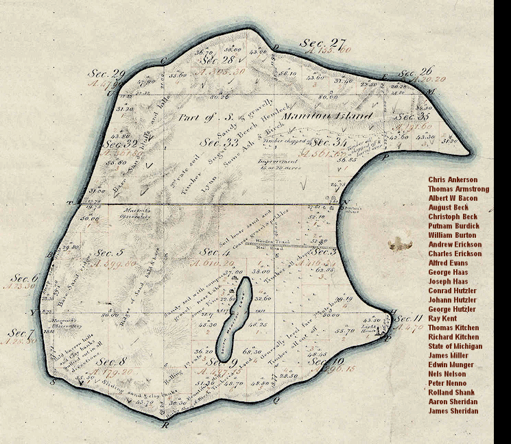
(5) Information provided by the Bureau of Land Management, General Land Office Records, including this map of the 1847 Orange Risdon Survey.
© 2011, ManitouIslandsArichivs.Org, All rights reserved.


